Ocean Parkway: A Scenic Route Through Long Island's Coastal Parks
The Ocean Parkway is a vital coastal artery on Long Island, providing access to some of New York's most beloved beaches and recreational facilities. Stretching from the heart of Jones Beach State Park to the shores of Captree State Park, this route offers a seamless transition between natural landscapes and essential infrastructure.
Key Facts
- Western Terminus: Cloverleaf interchange with Meadowbrook State Parkway and Bay Parkway.
- Eastern Terminus: Tollbooths in the town of Islip, leading to a marina and beach.
- Major Intersections: Wantagh State Parkway and the Robert Moses Causeway.
- Parks Traversed: Jones Beach, Tobay Beach, Gilgo, and Captree State Parks.
- Lane Configuration: Varies between four and six lanes depending on the section.
Journey Through Jones Beach and Tobay
The journey begins at a cloverleaf interchange where the Ocean Parkway meets the southern end of the Meadowbrook State Parkway and the Bay Parkway. As it heads east, the parkway parallels the Bay Parkway, hugging the beachfront and passing various recreational sites. This four-lane stretch provides access to the Jones Beach bathhouse and the Jones Beach Theatre via a dedicated turnoff.
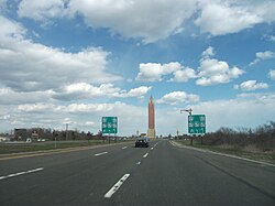
A notable landmark along this stretch is the Jones Beach Water Tower, known locally as "The Pencil," which sits at the center of a roundabout that marks the southern terminus of the Wantagh State Parkway.
Continuing eastward, the road runs between the beachfront and Zachs Bay, a part of South Oyster Bay. After leaving Jones Beach State Park, the parkway enters the town of Oyster Bay, passing south of Guggenheim Pond before entering Tobay Beach Park. In this section, the median expands, and a cross-under is provided to allow pedestrians to safely navigate the parkway to reach the bathhouse and parking areas.
Traversing Gilgo and Oak Beach
Upon leaving Tobay Beach Park, the Ocean Parkway enters Suffolk County and the Town of Babylon. In the hamlet of West Gilgo Beach, the road runs alongside residential properties before entering Gilgo Beach. Here, the parkway expands to six lanes to accommodate traffic near the Great South Bay and a pedestrian tunnel connecting the parking lot to the beach. Access to this parking lot is managed via a tolled entrance from the westbound lanes.
As the route enters Gilgo State Park, it maintains six lanes separated by a wide, grassy median. The road eventually passes the Cedar Beach Golf Course before entering the hamlet of Oak Beach. In this area, the parkway is uniquely positioned between the Atlantic Ocean and Oak Island.
The Final Stretch to Captree
As the parkway approaches the end of its route, it enters Captree State Park, where the median widens once more. The road then reaches a cloverleaf interchange with the Robert Moses Causeway.
After the causeway, the Ocean Parkway narrows back to four lanes as it enters the town of Islip. The eastern terminus is marked by a series of tollbooths. Beyond these tolls, the right-of-way concludes in a roundabout that provides access to a local marina and additional beach areas within Captree State Park.
| Section/Landmark | Key Feature | Location/Jurisdiction |
|---|---|---|
| Western Start | Meadowbrook State Parkway Interchange | Jones Beach State Park |
| "The Pencil" | Wantagh State Parkway Terminus | Jones Beach State Park |
| Tobay Beach | Pedestrian Cross-under | Town of Oyster Bay |
| Gilgo Beach | Six-lane expansion & Tolled Parking | Town of Babylon |
| Oak Beach | Route between Ocean and Oak Island | Hamlet of Oak Beach |
| Eastern End | Tollbooths & Marina Access | Town of Islip |
Frequently Asked Questions
Where does the Ocean Parkway begin and end?
The parkway begins at a cloverleaf interchange with the Meadowbrook State Parkway and Bay Parkway in Jones Beach State Park and ends at the tollbooths in the town of Islip within Captree State Park.
What is "The Pencil" on the Ocean Parkway?
"The Pencil" is the local nickname for the Jones Beach Water Tower, located at the roundabout that serves as the southern terminus of the Wantagh State Parkway.
Are there tolls on the Ocean Parkway?
Yes, there are tolled entrances for the Gilgo Beach parking lot from the westbound lanes, and tollbooths mark the eastern terminus of the parkway in Islip.
How many lanes does the Ocean Parkway have?
The parkway is primarily four lanes, but it expands to six lanes as it passes through Gilgo Beach and Gilgo State Park.
Which major causeway intersects the Ocean Parkway?
The Robert Moses Causeway intersects the Ocean Parkway via a cloverleaf interchange near the entrance to Captree State Park.