Mureș County: A Historical Overview of the Interwar Period
Located in the heart of Transylvania, Mureș County served as a vital administrative center in the central-northern region of Greater Romania during the interwar years. Originally known as Mureș-Turda County, the region underwent significant reorganization following the administrative unification law of 1925, which formally established it as Mureș County with its capital at Târgu Mureș.
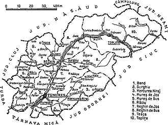
The county's geography placed it at a crossroads of several other administrative divisions. It was bordered by Târnava-Mică to the south, Turda to the southwest, Cluj to the west, and Năsăud to the north. To the northeast, it shared borders with Câmpulung and Neamț, while the southeast was bounded by Ciuc and Odorhei. While much of this historical territory remains part of the modern Mureș County, some northeastern areas are now in Harghita County, and northwestern sections are part of Bistrița-Năsăud County.
Key Facts
- Capital: Târgu Mureș
- Established: 1925 (as Mureș County)
- Total Area: 4,856 km²
- 1930 Population: 289,456
- Population Density: 59.61 inhabitants per km²
- Historic Region: Transylvania, Romania
Historical Evolution
Before World War I, the region was known as Maros-Torda County within the Kingdom of Hungary, part of the Austria-Hungary empire. Following the Treaty of Trianon in 1920, the territory was transferred to Romania.
The administrative structure shifted again in 1938 under King Carol II. The King introduced a new Constitution that replaced prefects with rezidenți regali (Royal Residents) and merged counties into larger regions called ținuturi (lands). Consequently, Mureș County became a part of Ținutul Mureș.
The mid-20th century brought further volatility. In 1940, the Second Vienna Award transferred the county back to Hungary as part of Northern Transylvania. However, by 1944, Romanian forces, supported by the Soviet Union, recaptured the area. This jurisdiction was formally reaffirmed in the 1947 Paris Peace Treaties. The county was later abolished by the communist government in 1950, only to be re-established in 1968 when Romania returned to the county administrative system.
Administrative Structure
The county was managed through districts known as plăși. Initially, the county consisted of seven districts: Band, Miercurea Nirajului, Râciu, Reghin, Târgu Mureș (also called Plasa Mureș), Teaca, and Toplița.
Following administrative adjustments, the number of districts increased to ten. This was achieved by dividing Plasa Mureș into Mureș de Jos (headquartered at Mureșeni) and Mureș de Sus (headquartered at Târgu Mureș), and dividing Plasa Reghin into Reghin de Jos (headquartered at Reghin) and Reghin de Sus (headquartered at Suseni). The other districts—Band, Gurghiu, Miercurea Nirajului, Râciu, Teaca, and Toplița—remained. The county featured two primary urban centers: the city of Târgu Mureș and the urban commune of Reghin.
Demographics and Society
The 1930 census reveals a highly diverse population. Ethnically, the county was composed of Romanians (45.8%), Hungarians (42.6%), Germans (3.9%), Romanies (3.9%), and Jews (3.4%). This diversity was mirrored in the languages spoken, with Hungarian (45.9%) and Romanian (45.5%) being the most prominent, followed by German (3.9%), Yiddish (2.2%), and Romany (2.1%).
Religious affiliation was equally varied, with Greek Catholics (32.4%) and Reformed Christians (30.3%) forming the largest groups, followed by Eastern Orthodox (14.5%) and Roman Catholics (12.1%).
Urban Population Trends
The urban population, totaling 47,807 people, differed significantly from the rural demographic. Hungarians made up the majority of city dwellers at 54.3%, followed by Romanians (24.3%) and Jews (13.4%). In terms of language, 61.2% of urban residents spoke Hungarian as their mother tongue, while 23.6% spoke Romanian. The urban religious landscape was led by the Reformed church (32.6%) and Roman Catholics (20.1%).
| Category | Total Population | Urban Population |
|---|---|---|
| Total Count | 289,456 | 47,807 |
| Primary Ethnicity | Romanian (45.8%) | Hungarian (54.3%) |
| Primary Language | Hungarian (45.9%) | Hungarian (61.2%) |
| Primary Religion | Greek Catholic (32.4%) | Reformed (32.6%) |
Frequently Asked Questions
When was Mureș County established?
Mureș County was established in 1925 following the administrative unification law, having previously been known as Mureș-Turda County.
What happened to the county in 1938?
In 1938, King Carol II reorganized the administrative divisions of Romania, merging counties into larger regions called ținuturi. Mureș County became part of Ținutul Mureș and was governed by a Royal Resident instead of a prefect.
How did the county's borders change over time?
Originally part of the Maros-Torda County of Austria-Hungary, it became part of Romania in 1920. It was briefly transferred back to Hungary in 1940 under the Second Vienna Award before being reintegrated into Romania in 1944.
What was the ethnic composition of the county in 1930?
The population was predominantly Romanian (45.8%) and Hungarian (42.6%), with smaller minorities of Germans (3.9%), Romanies (3.9%), and Jews (3.4%).
Which cities were considered urban localities in the historical county?
The county had two urban localities: the city of Târgu Mureș and the urban commune of Reghin.