Mount Baker Ridge Tunnel: Evolution of Seattle's I-90 Crossing
The Mount Baker Ridge Tunnel serves as a critical artery in Seattle's transportation network, linking the city's urban core with the east side via the I-90 floating bridges. From its origins as a modest twin-tunnel system in 1940 to its current role as a multi-modal corridor supporting light rail, the site reflects the rapid growth and changing transit needs of the Pacific Northwest.
The Original 1940 Configuration
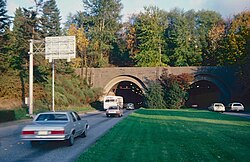
Completed in 1940, the original infrastructure consisted of twin tunnels connecting Rainier Avenue South in Seattle to the I-90 floating bridge on Lake Washington. At the time, these tunnels were part of US Highway 10, a four-lane undivided highway that utilized surface streets to reach downtown Seattle.
Each of the original tunnels housed two traffic lanes. Typically, the north tunnel handled westbound traffic while the south tunnel managed eastbound flow. To address peak commute demands in the 1960s, a lane-use signal system was introduced. This allowed the center two lanes to become reversible, shifting capacity to three lanes westbound in the mornings and three lanes eastbound in the evenings.
The 1983–1993 Expansion Project
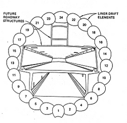
As the highway transitioned into the controlled-access Interstate 90, the existing capacity became insufficient. Construction began in 1983 on a new, larger parallel tunnel located north of the original pair. This new tunnel, completed in June 1989, featured a diameter of 63 feet (19 m), significantly larger than the 29-foot (8.8 m) diameter of the 1940 tunnels.
The 1989 tunnel was designed with a unique three-level vertical configuration to separate different modes of transport:
- Top Level: Dedicated to pedestrians and cyclists.
- Middle Level: Three lanes for general motor vehicle traffic.
- Bottom Level: Two lanes reserved for buses and carpools.
The integration of the new tunnel was complex. It initially connected to the new Homer M. Hadley Memorial Bridge. For a period between 1989 and 1993, the new tunnel carried all bidirectional traffic while the older Lacey V. Murrow Memorial Bridge and the 1940 tunnels underwent rehabilitation. A storm in 1990 caused a section of the Murrow Bridge to sink, delaying the full reopening of the system until 1993.
Structural Modifications and the "Lid"
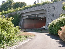
The expansion project also altered the physical footprint of the 1940 tunnels. The original west portal near 29th Avenue South was removed and replaced by a 2,000-foot-long (610 m) concrete lid—a structure covering the freeway to create surface-level space—extending to just west of 23rd Avenue South. While the lid is not officially part of the tunnel, the interior of the 1940 tunnels was modified from an arch shape to a square/rectangular profile to match the lid's geometry.
Current Operations and Modern Transit
Today, the I-90 corridor operates with three general-purpose lanes in each direction. Eastbound traffic utilizes the original 1940 tunnels, while westbound traffic uses the upper deck of the 1989 tunnel. The I-90 Trail tunnel, located above the westbound traffic, stands at 1,330 feet (410 m), making it the longest non-adapted trail tunnel in the world.
The lower deck of the 1989 tunnel, which previously served as reversible express lanes for buses and carpools, underwent a major transformation starting in 2017. These lanes were closed to accommodate the East Link light rail project, extending Link light rail service from Seattle to Bellevue and Redmond, which opened in March 2026.
Key Facts
- Original Tunnels: Built in 1940, 29 feet in diameter, each 1,466 feet long.
- 1989 Tunnel: 63 feet in diameter, featuring a three-level design.
- The Lid: A 2,000-foot concrete cover over the freeway west of the original portals.
- I-90 Trail: The world's longest non-adapted trail tunnel at 1,330 feet.
- Modern Use: Original tunnels are now eastbound-only; the 1989 tunnel supports westbound traffic and light rail.
| Feature | 1940 Twin Tunnels | 1989 Tunnel |
|---|---|---|
| Diameter | 29 feet (8.8 m) | 63 feet (19 m) |
| Current Direction | Eastbound only | Westbound / Light Rail |
| Internal Shape | Originally arched, now rectangular | Circular/Multi-level |
| Primary Use | General traffic | General traffic, Trail, and Rail |
Frequently Asked Questions
What happened to the reversible lanes in the 1989 tunnel?
The reversible express lanes on the lower deck were closed in June 2017 to make way for the construction of the East Link light rail extension.
How does the I-90 Trail tunnel connect to the city?
The trail tunnel runs above the westbound traffic; on its western half, it emerges onto the concrete lid and connects to trails within Lid Park.
Why were the 1940 tunnels modified to be rectangular?
The interior walls and ceilings were squared off to match the shape of the 2,000-foot concrete lid built over the freeway section.
Which bridge connects to which tunnel?
The original 1940 tunnels connect to the Lacey V. Murrow Memorial Bridge (southern bridge), while the 1989 tunnel connects to the Homer M. Hadley Memorial Bridge (northern bridge).
When did the light rail extension open?
The East Link light rail extension, which utilizes the space previously used by the express lanes, opened in March 2026.