Montgomeryshire: A History of the Welsh Border County
The history of Montgomeryshire is a narrative of strategic borders, shifting loyalties, and administrative evolution. Located on the frontier between England and Wales, this region transitioned from a medieval principality into a cornerstone of English authority in Wales, eventually evolving into the modern administrative structures seen today.
The Medieval Origins and the Treaty of Montgomery
The town of Montgomery was established as an English incursion on the Welsh side of the border to secure a strategic crossing. This location became the site of the Treaty of Montgomery, signed on September 29, 1267. At the time, the surrounding region was the principality of Powys Wenwynwyn, the southern portion of the former Kingdom of Powys.
Facing attacks from Gwynedd, the rulers of Powys Wenwynwyn sought English assistance. This alliance led to the territory becoming a marcher lordship—a border territory with special legal status—through a process of surrender and regrant. The ruling princes became the Lords of Powys, remaining independent in internal affairs while remaining feudally bound to the English king. During this era, the prince adopted the English-style surname Owen de-la Pole, named after his capital, Pool (modern-day Welshpool).
The Formation of Montgomeryshire
The transition from a lordship to a formal county occurred with the Laws in Wales Acts 1535–1542, which converted marcher lordships into English counties. The Lordship of Powys became Montgomeryshire. Although Welshpool was a center of Welsh authority, Montgomery was chosen as the county town because it represented the strongest center of English power in the region.
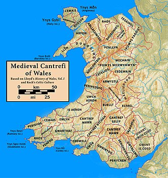
Montgomeryshire was primarily formed from the cantrefi (ancient Welsh land divisions) of Powys Wenwynwyn, including:
- Y Fyrnwy: Comprising the commotes of Mochnant Uwch Rhaeadr, Mechain Is Coed, and Llanerch Hudol.
- Llyswynaf: Comprising the commotes of Caereinion and Mechain Uwch Coed.
- Ystlyg: Comprising the commotes of Deuddwr, Ystrad Marchell, and Y Gorddwr Isaf.
- Cedewain: Comprising the commotes of Cynan, Cyfeiliog, and Mawddwy.
- Arwystli: Comprising the commotes of Arwystli Is Coed and Arwystli Uwch Coed.
For practical administrative reasons, the county also included the commote of Ceri, which had previously been part of the region known as Between Wye and Severn. Geographically, Montgomeryshire was bordered by Denbighshire to the north, Shropshire to the east and southeast, Radnorshire to the south, Cardiganshire to the southwest, and Merionethshire to the west and northwest.
Key Facts
- Welsh Name: The county is known in Welsh as Sir Drefaldwyn, often shortened to Maldwyn.
- Key Treaty: The Treaty of Montgomery (1267) was a pivotal moment in the region's political alignment.
- Notable Figure: Saint Richard Gwyn, a Welsh Catholic martyr, was born here in 1537.
- Administrative Shift: The region moved from a principality to a marcher lordship, then to a county, and finally into the unitary authority of Powys.
Local Government and Administration
Modern local government began with the Local Government Act 1888, which established elected county councils in 1889. These councils replaced the functions of the quarter sessions (local courts). While the county bore Montgomery's name, the council initially split its meetings between Newtown and Welshpool.
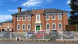
On April 1, 1889, the Montgomeryshire County Council held its first formal meeting at the Public Rooms (the Flannel Exchange) in Newtown. By 1931, the council established a permanent headquarters in Welshpool known as the Montgomeryshire County Offices, or Neuadd Maldwyn.
Until 1974, the county was organized into civil parishes, which largely mirrored ecclesiastical parishes. These were grouped into larger administrative units known as hundreds.
| Hundred | Associated Parishes |
|---|---|
| Cawrse | Crugion/Criggion, Forden/Ffordun |
| Deythur | Llandrinio, Llandysilio, Llansanffraid-ym-Mechain |
| Llanfyllin | Hirnant, Llanfihangel-yng-Ngwynfa, Llanfyllin, Llangynog, Llanwddyn, Meifod, Pennant-melangell |
| Llanidloes | Carno, Llandinam, Llangurig, Llanidloes, Llanwnnog, Penystrywaid/Penstrowed, Trefeglwys |
| Machynlleth | Cemais/Cemmaes, Darowen, Llanbrynmair, Llanwrin, Machynlleth, Penegoes |
| Mathrafal | Castell Caereinion, Garthbeibio, Llanerfyl, Llanfair Caereinion, Llangadfan, Llangynyw |
| Montgomery | Ceri/Kerry, Churchstoke, Hyssington, Mochdre, Montgomery, Snead |
| Newtown | Aberhafesp, Berriew, Bettws Cedewain, Llandyssil, Llanllugan, Llanllwchaearn, Llanmerewig, Llanwyddelan, Manafon, Newtown, Tregynon |
| Pool | Buttington, Guilsfield, Llanfechain, Welshpool |
Modern Reforms and the Transition to Powys
Significant restructuring occurred in 1974 when Montgomeryshire, Radnorshire, and Brecknockshire were merged to form the administrative county of Powys. A lower-tier Montgomeryshire district was created, which continued to use Neuadd Maldwyn as its headquarters and maintained an area office at Newtown Hall Park.
In 1996, district councils in Wales were abolished, and Powys became a unitary authority (a single-tier administration). A Montgomeryshire area committee was maintained until 2018, covering the former district and three communities transferred from the Glyndŵr district of Clwyd.
Frequently Asked Questions
Why was Montgomery chosen as the county town over Welshpool?
Montgomery was selected because it was the strongest center of English authority in the region, whereas Welshpool was a center of Welsh authority.
What was the significance of the Treaty of Montgomery?
Signed in 1267, the treaty was a key diplomatic event in the town of Montgomery, which had been established to control a strategic border crossing.
What is Neuadd Maldwyn?
Neuadd Maldwyn is the headquarters building of the former Montgomeryshire County Council, opened in Welshpool in 1931.
How did the region change during the Laws in Wales Acts?
The Acts of 1535–1542 converted the marcher lordships, including the Lordship of Powys, into English counties, officially creating Montgomeryshire.
What is the current administrative status of Montgomeryshire?
Since 1996, it has been part of the Powys unitary authority, following the abolition of district councils in Wales.