Monsoon Trough Dynamics: The Engine of Tropical Rainfall and Cyclogenesis
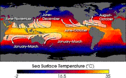
The monsoon trough is a critical atmospheric feature acting as a convergence zone between the wind patterns of the Northern and Southern Hemispheres. As a specific portion of the Intertropical Convergence Zone (ITCZ) in the Western Pacific, it is identified on weather maps by lines indicating areas of minimum sea level pressure. This zone serves as a massive atmospheric meeting point where different wind systems collide, creating the conditions necessary for heavy precipitation and intense storm development.
Within the trough, wind patterns are distinct: westerly monsoon winds occupy the equatorward side, while easterly trade winds prevail poleward of the axis. This convergence along the trough's axis triggers heavy rainfall, which often marks the peak of the rainy season for various regions and plays a vital role in the creation and maintenance of the world's rainforests.
Key Facts
- The monsoon trough is a convergence zone of wind patterns between the Northern and Southern Hemispheres.
- It is a primary driver for the onset of annual rainy seasons in Asia and Australia.
- The trough is a significant region for tropical cyclogenesis (the formation of tropical cyclones).
- Monsoon depressions can produce a year's worth of rainfall in just a few days.
- The trough's position and orientation significantly influence the movement tracks of tropical cyclones.
Movement and Seasonal Strength
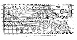
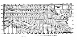
The strength and position of the monsoon trough shift dramatically with the seasons. In the Western Pacific, troughing reaches its maximum latitude during late summer, coinciding with the period when the wintertime surface ridge in the opposite hemisphere is at its strongest. In East Asia, the trough can reach as far as the 40th parallel during August, while in Australia, it can reach the 20th parallel in February.
This poleward movement is accelerated by the onset of the summer monsoon, driven by the development of low air pressure over the warmest parts of various continents. In the Southern Hemisphere, the Australian monsoon trough reaches its most southerly position in February, typically oriented along a west-northwest/east-southeast axis. Large-scale geographical features, such as the Plateau of Tibet or mountain barriers like the Andes and the Rockies, also exert influence on these atmospheric flows.
The Role of Wind Surges and Vorticity
The intensity of the monsoon trough is often linked to relative vorticity, or the "spin" of the atmosphere. An increase in vorticity is typically caused by heightened wind convergence within the trough. Wind surges—sudden increases in wind speed—can drive this convergence. For instance, a strengthening or equatorward movement of the subtropical ridge can push a wind surge toward the trough, intensifying it.
Interestingly, wind surges can cross the equator in oceanic regions as fronts move through the subtropics during their respective winters. This can enhance the monsoon trough in the opposite hemisphere's summer. Meteorologists often detect the arrival of a wind surge when a sudden burst of thunderstorms forms within the trough.
Monsoon Depressions: Powerful Rainfall Producers
When a circulation forms within the monsoon trough, it may compete with the neighboring thermal low over a continent, triggering a wind surge at its periphery. This broad circulation is known as a monsoon depression. In the Northern Hemisphere, these systems are generally asymmetric, with their strongest winds located on the eastern periphery. While the center may experience light and variable winds, the surrounding area is characterized by intense bands of showers and thunderstorms.
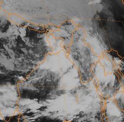
The development of a monsoon depression can be enhanced by an upper-level jet stream located poleward and west of the system. This leads to increased diverging air aloft, which causes surface pressure to drop. While these systems can develop over land, their outer structures are remarkably similar to tropical cyclones. In India, approximately 6 to 7 monsoon depressions cross the country annually, with frequency increasing in the Bay of Bengal during July and August of El Niño events. These systems are incredibly efficient at producing rain; in dry areas like the Australian outback, a single depression can deliver a year's worth of rainfall in a matter of days.
The Joint Typhoon Warning Center (JTWC) officially recognized "monsoon depression" as a category in 2015, noting Cyclone Komen as the first system to be classified as a fully realized monsoon depression.
Impact on Tropical Cyclone Formation
The monsoon trough is a major breeding ground for tropical cyclones. The environment within the trough is rich in low-level vorticity, providing the necessary rotation for cyclogenesis. This process follows a roughly 15- to 25-day cycle of thunderstorm activity, mirroring the patterns seen in the Madden–Julian oscillation (MJO), where clusters of activity are followed by periods of relative calm.
The orientation of the trough also dictates the path of these storms:
- Normal Orientation (E-SE to W-NW): Tropical cyclones along the periphery tend to move westward.
- Reverse Orientation (SW to NE): Tropical cyclones tend to move more poleward, often resulting in S-shaped tracks.
Furthermore, the latitude of the trough is a key factor in storm frequency. In the Pacific, when the monsoon trough lies near 20 degrees north latitude, the frequency of tropical cyclones is 2 to 3 times higher than when it is located closer to 10 degrees north.
Summary of Monsoon Trough Characteristics
| Feature | Description | Primary Impact |
|---|---|---|
| Convergence Zone | Meeting point of westerly and easterly winds | Heavy rainfall and thunderstorm formation |
| Monsoon Depression | Broad circulation within the trough | Extreme rainfall events (up to a year's worth) |
| Vorticity | Atmospheric "spin" or rotation | Facilitates tropical cyclone genesis |
| Trough Orientation | Direction of the trough axis | determines cyclone movement tracks
Frequently Asked Questions
What is the difference between the ITCZ and the monsoon trough?
The monsoon trough is a specific portion of the Intertropical Convergence Zone (ITCZ), primarily located in the Western Pacific, characterized by the convergence of monsoon wind patterns.
How does a monsoon trough affect the rainy season?
The trough acts as a focus for low-level moisture. When it moves into a landmass, such as the abrupt northward movement seen in South and East Asia between May and June, it heralds the beginning of the annual rainy season.
Can a monsoon depression form over land?
Yes, monsoon depressions can develop over land. However, their outer portions exhibit characteristics very similar to those of tropical cyclones.
Why are tropical cyclones more frequent at certain latitudes in the Pacific?
The frequency of tropical cyclones is highly dependent on the position of the monsoon trough. For example, when the trough is near 20 degrees north latitude, cyclone frequency is significantly higher than when it is near 10 degrees north.
What causes the "spin" in a monsoon trough?
The increase in relative vorticity, or spin, is typically a product of increased wind convergence within the convergence zone of the trough, often driven by wind surges.