Lafitte Greenway: New Orleans' Historic Urban Trail
The Lafitte Greenway is a premier pedestrian and bicycle trail in New Orleans, Louisiana. Stretching from Louis Armstrong Park to Bayou St. John and beyond, this urban corridor serves as a vital link between diverse neighborhoods, offering a safe, scenic route for commuters and recreationists alike.
Opened officially on November 6, 2015, the Greenway is more than just a path; it is the modern reconfiguration of a transportation corridor that has served the city for over two centuries, evolving from a canal to a railway and finally into a public parkway.
Key Facts
- Length: 2.6 miles from Basin Street to Alexander Street.
- Connectivity: Links the French Quarter to Lakeview via Tremé, Lafitte, and Mid-City.
- Opening Date: November 6, 2015.
- Initial Cost: $9.1 million for the first phase.
- Funding: Primarily funded through Disaster Community Development Block Grants (CDBG-D) following Hurricane Katrina.
Trail Description and Design
The Greenway extends 2.6 miles, beginning at the Basin Street trailhead near the Municipal Auditorium in Armstrong Park and ending at the Alexander Street trailhead. By traversing the Tremé, Lafitte, and Mid-City areas, the trail effectively connects the heart of the city to the Lakeview neighborhood.
The design focuses on sustainability and urban resilience. The landscaping incorporates native plantings and bioswales—landscape elements designed to concentrate or remove pollution from surface runoff water—as part of innovative stormwater management proposals.
Beyond the trail itself, the City of New Orleans has implemented a revitalization plan intended to stimulate economic investment and development along the corridor.
A Legacy of Transportation
The land occupied by the Lafitte Greenway has been a transportation artery since at least 1794. Its history is a timeline of New Orleans' industrial evolution:
- The Carondelet Canal: The earliest iteration of the corridor.
- Southern Railway: The land was later used by the Southern Railway (now Norfolk Southern Railway) to provide passenger trains access to the Southern Railway Terminal on Basin Street at Canal.
- Transition: This rail usage continued until the New Orleans Union Passenger Terminal was established in 1954.
The vision for a public greenway began in the 1970s, championed by architect Clifton James and civil rights activists including Rudy Lombard. For years, the project remained a dream, with activists organizing annual hikes starting in 2005 to raise awareness, leading hundreds of people to trek across the rough, undeveloped terrain.
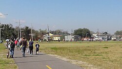
The path to completion faced hurdles; in 2006, a large portion of the land was sold to the Louisiana Institute of Film Technology. When plans for a studio failed to materialize, the Trust for Public Land brokered a deal in 2010 to return the land to public ownership.
Future Expansion
The city aims to extend the Greenway by another half-mile, pushing further into the Lakeview neighborhood toward Canal Boulevard. This proposed extension would run parallel to an active rail line used by a local brickyard. The City of New Orleans is currently in negotiations with Norfolk Southern to make this expansion possible.
| Feature | Details |
|---|---|
| Total Current Length | 2.6 Miles |
| Primary Access Points | Basin Street & Alexander Street |
| Neighborhoods Served | Tremé, Lafitte, Mid-City |
| Key Funding Source | CDBG-D (Post-Katrina) |
| Proposed Extension | 0.5 Miles to Canal Boulevard |
Frequently Asked Questions
Where does the Lafitte Greenway start and end?
The trail currently runs 2.6 miles from the Basin Street trailhead near the Municipal Auditorium in Louis Armstrong Park to the Alexander Street trailhead.
How was the construction of the Greenway funded?
The initial phase, which cost $9.1 million, was largely funded through Disaster Community Development Block Grants (CDBG-D) allocated after Hurricane Katrina.
What was the land used for before it became a trail?
The corridor has a long history as a transportation route, previously serving as the Carondelet Canal and later as a rail line for the Southern Railway.
What are bioswales and why are they used on the trail?
Bioswales are landscaped channels designed to manage stormwater by filtering pollutants from runoff, contributing to the Greenway's sustainable water design.
Are there plans to make the trail longer?
Yes, the City of New Orleans plans to extend the trail another half-mile into the Lakeview neighborhood to reach Canal Boulevard, pending negotiations with Norfolk Southern.