La Siberia: The Water Heartland of Extremadura
Located in the northeastern reaches of the province of Badajoz within the autonomous community of Extremadura, La Siberia is a region of striking contrasts. From its prehistoric roots to its status as a critical water hub for Spain, this comarca (a traditional Spanish administrative district) blends rugged mountain foothills with vast, water-rich plains.
With its capital in Herrera del Duque, La Siberia serves as a geographical bridge, bordered by the provinces of Cáceres and Toledo to the north, Ciudad Real to the east, the La Serena comarca to the south, and Las Vegas Altas to the west.
Key Facts
- Water Wealth: Contains the largest amount of freshwater in the entire Iberian Peninsula.
- Major Landmark: Home to the La Serena reservoir, the largest reservoir in Spain.
- Biodiversity: Designated as a Special Protection Area (SPA) for endangered birds.
- Geography: Features the longest inland coastline of any region in Spain due to its extensive reservoir systems.
- Economy: Primarily driven by livestock due to erosion-prone peneplains (low-relief plains).
Ancient Roots and Prehistory
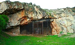
The history of La Siberia begins in prehistory, inhabited by semi-nomadic hunter-gatherers. Evidence of this early human presence survives through stone tools and rupestrian (rock-based) cave paintings. While the most prolific examples are found in the nearby Maltravieso Cave—dating back to the Aurignacian era—the region as a whole reveals a deep connection to early human settlement through discovered ceramics and human remains.
Geography and the Power of Water
The terrain of La Siberia is diverse, dominated by the foothills of the Montes de Toledo in the north and the flatter Sierra Morena in the south. The landscape is defined by two major river systems: the Guadiana and the Zujar.
The Guadiana River traverses the comarca from northeast to southwest, eventually forming a significant portion of the border between Spain and Portugal. To manage these resources, several massive reservoirs have been constructed, including the Cijara, García de Sola, and Orellana. In the south, the Zujar River feeds the Zujar and La Serena reservoirs.
The scale of these water resources is immense. The five primary reservoirs have a combined maximum capacity of approximately 6.395 billion cubic meters, representing about 12% of Spain's total water resources. The La Serena reservoir alone accounts for 6% of the nation's water.
| Category | Details |
|---|---|
| Capital | Herrera del Duque |
| Number of Municipalities | 18 |
| Total Area | 2,943 km² |
| Population (2015) | 21,422 |
| Population Density | 7.55 / km² |
| Primary Rivers | Guadiana, Zujar |
Flora, Fauna, and Outdoor Life
Due to a low population density—significantly lower than the Spanish national average—La Siberia remains a sanctuary for nature. The landscape is dominated by oak trees, alongside chestnut, ash, willow, eucalyptus, and pine.
The region is a critical habitat for avian species, leading to its designation as a Special Protection Area (SPA). It supports endangered populations of owls and Eurasian black vultures, as well as common species like pigeons and doves.
Hunting and Fishing
Outdoor pursuits are central to local culture. Small game hunting is popular, with the red-legged partridge being the most prized, alongside quail, rabbits, and foxes. Larger game, including wild boar, deer, ibexen, and mouflon, are also found in the region.
The abundant waters support a variety of fish. Native species include the Iberian nase, common barbel, brown trout, and tench, while introduced species such as black bass, carp, and pumpkinseed have also become established.
Climate and Transition Zones
La Siberia acts as a climatic transition zone. The northern reaches experience a continental climate, while the majority of the region falls under a Mediterranean climate. This results in long, hot summers and short, moderately cold winters.
The region is relatively dry, receiving an average of 463 mm of precipitation annually, which is below the Spanish average. December is typically the wettest month, while July is the driest, often seeing as little as 4 mm of rain.
Frequently Asked Questions
What is the most significant water feature in La Siberia?
The La Serena reservoir is the most significant, as it is the largest reservoir in Spain and the second largest in Europe, holding 6% of Spain's total water resources.
Why is livestock the main economic activity in the region?
The region's peneplains have suffered from erosion, resulting in poor soil quality that makes the land poorly suited for large-scale agriculture, leading the population to rely on livestock.
Which prehistoric site is most associated with the area?
The Maltravieso Cave is the most prolific site, featuring Aurignacian era cave paintings, ceramics, and human remains.
What makes La Siberia a Special Protection Area (SPA)?
It is designated as an SPA because of its large populations of endangered bird species, specifically owls and Eurasian black vultures.
How does the population density of La Siberia compare to the rest of Spain?
La Siberia is very sparsely populated, with just under 10 inhabitants per square kilometer, compared to the Spanish national average of approximately 70 per square kilometer.