Korean Demilitarized Zone: The Divided Border of the Peninsula
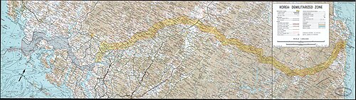
The Korean Demilitarized Zone (DMZ) is one of the most heavily fortified borders in the world. Established to serve as a buffer between North and South Korea, it represents the physical and political division of the Korean Peninsula. While designed to prevent the flare-up of hostilities, the zone remains a site of high tension, operational military presence, and surprising ecological preservation.
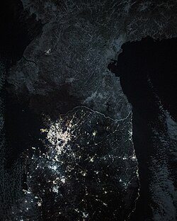
From space, the DMZ is strikingly visible at night; the northern half of the peninsula remains dark, creating a sharp contrast with the brightly lit South.
Key Facts

- Length: 238 kilometers (148 miles).
- Established: July 27, 1953, following the Korean War.
- Purpose: To act as a buffer zone between North and South Korea.
- Management: Access is granted by the United Nations Command or North Korea.
- Status: Fully manned and operational.
History and Establishment
The DMZ was created as part of the armistice agreement that ended the active fighting of the Korean War. It was built through the combined efforts of the United States, China, North Korea, South Korea, and the United Nations Command. The zone is centered around the Military Demarcation Line (MDL), which serves as the actual border.

Over the decades, the zone has evolved from a simple ceasefire line into a complex system of fortifications. This includes the Civilian Control Line, a restricted area outside the DMZ intended to protect civilians and secure the military perimeter.
The Joint Security Area (JSA)
The Joint Security Area, located at Panmunjon, is the only place where North and South Korean forces stand face-to-face. It is the primary site for diplomatic negotiations and high-level meetings. Notably, it was the site of the historic meeting between U.S. President Donald Trump and the leaders of North and South Korea, marking the first time an American president entered the zone.

Within the JSA, "Conference Row" consists of blue buildings that straddle the border, allowing representatives from both sides to meet in a neutral environment.

Military Fortifications and Incursions
Despite its name, the "demilitarized" zone is heavily armed. The North Korean side is characterized by electric fences and extensive minefields designed to prevent defections and infiltrations.

Infiltration Tunnels
One of the most significant security discoveries in the DMZ has been the series of infiltration tunnels dug by North Korea. These tunnels were designed to allow troops to move undetected into South Korean territory. To date, four major tunnels have been identified, including the 4th Infiltration Tunnel, which is now open to the public as a testament to the region's volatility.

Propaganda and Psychological Warfare
For years, the DMZ was a battleground for psychological warfare. Both sides utilized massive loudspeaker installations to blast propaganda and music across the border. Additionally, balloons carrying leaflets have been used to transmit messages between the two nations. While there have been periods of dismantling these systems during diplomatic thaws, they remain a tool of political pressure.
Life and Nature in the DMZ
Because human access has been strictly limited for over 70 years, the DMZ has inadvertently become a massive nature reserve. The absence of urban development has allowed rare wildlife to thrive, including the Asiatic Black Bear and various species of foxes and tigers.
Beyond the wildlife, a few isolated villages exist, such as Kijŏng-dong in the North, which is often viewed by visitors from the South as a propaganda village.

Transportation and Tourism
In recent years, limited tourism has developed on the South Korean side. The DMZ Train tour organized by Korail and the "Peace Trail" in Goseong County allow visitors to glimpse the border. On the east coast, the Donghae Bukbu Line was specifically developed to facilitate South Korean visits to the Mount Kumgang Tourist Region in the North.


Summary of the Korean DMZ
| Feature | Details |
|---|---|
| Total Length | 238 km (148 mi) |
| Established Date | July 27, 1953 |
| Key Diplomatic Site | Joint Security Area (JSA) |
| Primary Hazards | Landmines and electric fences |
| Notable Infrastructure | Infiltration tunnels and Conference Row |
Frequently Asked Questions
What is the purpose of the Korean DMZ?
The DMZ serves as a buffer zone between North and South Korea to prevent military conflicts and maintain the ceasefire established at the end of the Korean War in 1953.
Can tourists visit the DMZ?
Yes, but access is strictly controlled. Visitors typically enter through authorized tours organized by the United Nations Command or the South Korean government, with specific checkpoints like the Civilian Control Line.
What are the infiltration tunnels?
These are secret underground passages dug by North Korea to move soldiers into South Korea undetected. Several have been discovered and some are now open as tourist sites.
Why is the DMZ considered a nature reserve?
Because the area has been off-limits to most humans for over seven decades, the land has remained undisturbed, allowing endangered species and native flora to flourish without urban interference.
What is the Joint Security Area (JSA)?
The JSA is a specific area within the DMZ where North and South Korean soldiers stand face-to-face and where diplomatic meetings and negotiations take place.