KNMI: The Royal Netherlands Meteorological Institute
The Royal Netherlands Meteorological Institute (Dutch: Koninklijk Nederlands Meteorologisch Instituut, or KNMI) serves as the national weather forecasting service for the Netherlands. Headquartered in De Bilt, in the province of Utrecht, the institute is a critical pillar of Dutch infrastructure, providing essential data on weather, climate, and seismic activity.
Operating under the Ministry of Infrastructure and Water Management, KNMI functions as the national research and information center for climate change and seismology. Its work ensures that the Dutch government and the general public have access to accurate meteorological data to navigate the challenges of a changing environment.
Key Facts
- Founded: 31 January 1854 by royal decree of King William III.
- Headquarters: De Bilt, Netherlands.
- Workforce: 534 employees (as of 2024).
- Primary Roles: Weather forecasting, climate monitoring, and seismic activity tracking.
- Leadership: Directed by Maarten Krispijn van Aalst.
- Responsible Minister: Robert Tieman, Minister of Infrastructure and Water Management.
History and Evolution
KNMI was established in 1854 as the "Royal Meteorological Observatory." Its first director, Professor C. H. D. Buys Ballot, was a pioneer in the field. Dissatisfied with the non-scientific weather reports common in European newspapers at the time, Ballot introduced the concept of weervoorspelling (weather prognostication), establishing a foundation for daily scientific weather predictions.
Initially, the institute was divided into two specialized branches: a land branch led by Dr. Frederik Wilhelm Christiaan Krecke and a marine branch led by navy Lt. Marin H. Jansen. While the institute began its operations at the Sonnenborgh fort in Utrecht, it eventually moved its headquarters to the Koelenberg estate in De Bilt in 1897.
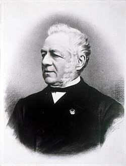
![Maurits Snellen [nl], 2nd director(from 1890 to 1902)](/images/21/89/21895845baa5f25544511e12031a9516013ae2c83c28bbfbb2dfe00208870615.jpg)
Core Research Areas
KNMI conducts applied research across three primary domains to improve operational accuracy and policy support:
- Meteorology and Oceanography: Enhancing the quality and accessibility of data to support operational weather forecasting.
- Climate Science: Studying atmospheric boundary layer processes, clouds, radiation, and the chemical composition of the atmosphere (such as ozone). This research includes analyzing climate variability and providing policy support to the Dutch Government.
- Seismology: Monitoring seismic activity and conducting research into earthquakes.
Atmospheric Dispersion Modeling and Emergency Response
A specialized area of KNMI's research is the development of atmospheric dispersion models—tools used to predict how toxic gases or radioactive materials travel through the air during a disaster.
To manage these crises, KNMI maintains a calamity service with seven meteorologists on call 24/7. This service integrates with municipal and provincial disaster management plans, providing real-time data to police, fire departments, and civil services via dedicated telephone lines.
The PUFF Model
Developed in collaboration with the National Institute for Public Health and the Environment (RIVM), PUFF is designed for European-scale air pollution dispersion. It was notably tested using data from the 1986 Chernobyl nuclear accident and the 1994 European Tracer Experiment (ETEX).
The CALM Model
The CALM (Calamity Model) is used for small-scale dispersion calculations within the Netherlands. While it uses algorithms similar to PUFF, CALM requires manual meteorological input, including mixing height, atmospheric stability classification, and wind velocity at 10 meters. The result is a map showing the trajectory and dispersion of the pollution plume.
Storm Naming
In 2019, KNMI joined the western storm naming group to increase public awareness of storm dangers. The first storm named under this initiative was Storm Ciara on 9 February 2020.
Agency Summary
| Attribute | Details |
|---|---|
| Official Name | Koninklijk Nederlands Meteorologisch Instituut |
| Established | January 31, 1854 |
| Location | De Bilt, Utrecht, Netherlands |
| Parent Department | Ministry of Infrastructure and Water Management |
| Key Functions | Weather, Climate, and Seismology |
| Staff Count | 534 (2024) |
Frequently Asked Questions
What are the primary responsibilities of KNMI?
KNMI is responsible for national weather forecasting, monitoring climate changes, and tracking seismic activity (earthquakes) within the Netherlands.
How does KNMI assist during environmental disasters?
KNMI operates a 24/7 calamity service that uses atmospheric dispersion models (PUFF and CALM) to predict the movement of toxic or radioactive plumes, providing critical data to emergency services.
What is the difference between the PUFF and CALM models?
PUFF is used for large-scale dispersion across Europe, whereas CALM is designed for small-scale dispersion specifically within the Netherlands and requires manual data entry for meteorological inputs.
When did KNMI start naming storms?
KNMI joined the western storm naming group in 2019, and the first named storm was Storm Ciara in February 2020.
Who founded the institute and why?
The institute was established by King William III in 1854. Its first director, C. H. D. Buys Ballot, sought to replace non-scientific newspaper reports with rigorous, scientific weather predictions.