Karoo: The Vast Semidesert Heart of South Africa
The Karoo is a sprawling semidesert region of South Africa that has long fascinated and intimidated those who traverse it. Once viewed by early explorers as an impenetrable barrier characterized by extreme heat, bitter frosts, and erratic cycles of flood and drought, it remains a land of dramatic contrasts. With annual rainfall ranging from 50 to 250 mm (2.0–9.8 in), the plains are arid, though surrounding mountains can receive an additional 250 to 500 mm of precipitation.
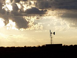
Despite the harsh surface conditions, the region is sustained by extensive underground water reserves. The introduction of boreholes and windpumps in the late 1800s transformed the landscape, enabling permanent human settlement and the establishment of a thriving sheep farming industry.
Key Facts
- Geography: Divided into the Great Karoo and the Klein Karoo, separated by the Swartberg Mountains.
- Climate: Extreme temperature fluctuations with very low annual rainfall (50–250 mm).
- Geology: Dominated by the Karoo Supergroup, featuring erosion-resistant dolerite sills that create flat-topped hills.
- Astronomy: Home to the Southern African Large Telescope (SALT) and the Square Kilometer Array (SKA) due to tectonic stability and clear skies.
- Biodiversity: Split into two distinct botanical regions: the Succulent Karoo and the Nama Karoo.
Regional Divisions
The Great Karoo
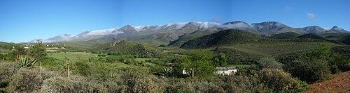
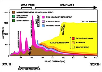
The Great Karoo is bounded to the south and southwest by the inland ranges of the Cape Fold Mountains. Its northern and eastern borders are less defined, gradually blending into the arid Bushmanland, the grasslands of the Highveld, and the Eastern Midlands. The region is further split by the Great Escarpment—a major geological slope—into the Upper Karoo (above 1,200–1,500 m) and the Lower Karoo (700–800 m).
The Lower Karoo includes subregions such as the Tankwa Karoo, Moordenaarskaroo, the Koup, the Vlakte, and the Camdeboo Plains. The Upper Karoo is known for areas like the Hantam, Kareeberge, Roggeveld, and Uweveld.
![A stylized illustration of the Great Escarpment, based particularly on its appearance in the Great Karoo, where thick erosion resistant dolerite sills (see below; represented here by the thick black lines. The thinner dolerite sills are not drawn in this diagram to avoid clutter) generally form the upper, sharp edge of the escarpment. (In other parts of the escarpment, hard erosion-resistant geological layers similarly form the upper, abrupt edge.) Note the island remnants of the earlier extent of the plateau on the plain below the escarpment (the Lower Karoo), left behind as the escarpment has gradually eroded further inland.[12]](/images/d5/1e/d51e47a42af9e71c52a04fac4f2bf5f25bf20687a707b26308a47c46cc38cae4.jpg)
The Klein Karoo
The Klein Karoo is a valley approximately 290 km (180 mi) long and 40 to 60 km (25–37 mi) wide. It is nestled between two parallel Cape Fold Mountain ranges: the Swartberg to the north and the Langeberg-Outeniqua range to the south. The northern strip of this valley is particularly fertile and well-watered, supporting towns such as Oudtshoorn, Calitzdorp, and Montagu.
Geology and Landscape
The Karoo Supergroup
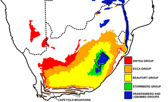
Geologically, the region is defined by the Karoo Supergroup, a sequence of sedimentary and igneous rocks between 180 and 310 million years old. This massive formation covers two-thirds of South Africa and extends deep into the earth, reaching depths of 8,000 m (26,000 ft). These rocks were once part of the ancient supercontinent Gondwana.
Formation of the Karoo Koppies
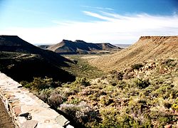
The landscape was shaped by massive lava outpourings that left a 1.6 km thick layer of basaltic lava. Some of this lava forced its way between sedimentary layers to form dolerite sills (horizontal sheets of igneous rock) and vertical dikes. Over 150 million years of erosion stripped away softer sediments, leaving the resistant dolerite sills as flat-topped hills known as Karoo Koppies.

Astronomy and Science
The Upper Karoo is one of the world's premier sites for astronomical observation. Its high altitude, lack of artificial light pollution, and clear skies are complemented by total tectonic inactivity, meaning there are no nearby fault lines or earthquakes to disturb sensitive equipment.
Key installations include the South African Astronomical Observatory, which houses the Southern African Large Telescope (SALT)—the largest optical telescope in the Southern Hemisphere—and the Square Kilometer Array (SKA), a massive radio telescope project designed to survey the Milky Way and the wider universe.
Flora and Fauna
Botanical Biomes
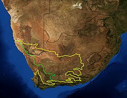
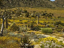
The region is divided into two primary botanical regions: the Succulent Karoo to the west and the Nama Karoo to the east.
Wildlife History
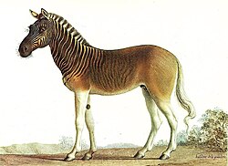
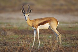
Historically, the Great Karoo supported diverse game, including the springbok, wildebeest, and the now-extinct quagga. The quagga, a subspecies of zebra, was hunted to extinction by the mid-1800s, with the last individual dying in an Amsterdam zoo in 1883. Today, the largest predators are the caracal, black-backed jackal, and various eagles, though leopards still inhabit the mountains.
In the Klein Karoo, the ostrich thrives. In the 1860s, farmers discovered that ostriches could be domesticated and bred in captivity. This led to a massive feather export industry, peaking in the early 20th century.
Human History and Settlement
The region was originally inhabited by Khoe-speaking clans and !Ui-speaking peoples who lived in small family groups. Because of the aridity, Ntu-speaking agriculturalists generally avoided the area. European penetration began in the mid-1700s with the trekboers, nomadic settlers who faced extreme environmental hardships.
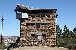
During the Second Anglo-Boer War (1899–1902), the Karoo became a site of guerrilla warfare and attrition. Strategic blockhouses were constructed along railway lines to control movement, many of which remain as historical landmarks today.
Summary of Karoo Regions
| Feature | Great Karoo | Klein Karoo |
|---|---|---|
| Topography | Vast plains and high plateaus | Narrow valley between mountain ranges |
| Key Boundaries | Cape Fold Mountains (South) | Swartberg (North), Langeberg (South) |
| Water Availability | Primarily underground (boreholes) | Streams and rain in northern strip |
| Notable Wildlife | Springbok, historically Quagga | Ostrich, Mountain Zebra |
| Key Industries | Sheep farming, Astronomy | Ostrich farming, Agriculture |
Frequently Asked Questions
What are Karoo Koppies?
Karoo Koppies are the characteristic flat-topped hills found throughout the landscape. They were formed when erosion-resistant dolerite sills remained after the surrounding softer sedimentary rocks were worn away over millions of years.
Why is the Karoo ideal for telescopes?
The region offers high altitude, clear skies, and an absence of artificial light. Most importantly, it is tectonically inactive, meaning there are no earthquakes or tremors to interfere with the precision of the telescopes.
What is the difference between the Succulent and Nama Karoo?
These are two separate botanical biomes. The Succulent Karoo is located to the west and is characterized by a high density of succulent plants, while the Nama Karoo lies to the east.
How did people survive in such an arid environment?
While early inhabitants relied on natural springs and gathering, permanent large-scale settlement and sheep farming became possible in the late 1800s with the introduction of the windpump, which allowed farmers to tap into deep underground water reserves.
What happened to the quagga?
The quagga was a gentle, zebra-like animal that roamed the Karoo in large numbers. Due to sport hunting, they were driven to extinction, with the last known individual dying in 1883.