Iraq–Kuwait Border: History, Demarcation, and Security
The border between Iraq and Kuwait is a 254 km (158 mi) boundary that serves as a critical geopolitical dividing line in the Persian Gulf region. Stretching from the tripoint with Saudi Arabia in the west to the coast of the Persian Gulf in the east, this border has been the subject of intense diplomatic disputes, military conflict, and rigorous international demarcation.
Key Facts
- Total Length: 254 km (158 mi).
- Primary Landmark: The Wadi al-Batin (a seasonal riverbed) defines much of the western boundary.
- Security Infrastructure: A 120-mile electrified fence and a subsequent 135-mile iron barrier.
- Legal Basis: Currently based on the 1932 confirmation and 1992 United Nations demarcation.
- Key Settlements: Safwan and Umm Qasr (Iraq); Abdali (Kuwait).
Border Geography and Description
The boundary begins in the west at the tripoint where Iraq, Kuwait, and Saudi Arabia meet on the Wadi al-Batin. From this point, the border follows the flow of the wadi as it moves north-eastwards. The line then shifts east, following a straight path for 32 km (20 mi), before veering south-east for another 26 km (16 mi). The land border terminates at the coast at the junction of the Khawr Abd Allah and Khor as Subiyah, opposite Hajjam Island.
Historical Evolution
Early 20th Century and the Ottoman Era
Historically, this region lacked a clearly defined boundary. From 1875 until the end of World War I, Kuwait fell under the de jure (legal) administration of the Basra Vilayet. By the early 1900s, the Ottoman Empire controlled Iraq, while the United Kingdom maintained de facto (actual) control over Kuwait as a protectorate.
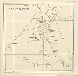
In 1913, the Anglo-Ottoman Convention attempted to divide these spheres of influence using "Blue" and "Violet" lines. The Ottomans recognized British claims to Kuwait, separating it from Ottoman Mesopotamia along the Wadi al-Batin, known as the "green line." However, this convention was never ratified and became moot with the outbreak of World War I.
Independence and Mid-Century Disputes
Following the Arab Revolt and the 1916 Sykes-Picot Agreement, the UK gained control of the Mosul, Baghdad, and Basra Vilayets. These became mandatory Iraq in 1921. When Iraq gained independence in 1932, the UK confirmed the border along the Wadi al-Batin and recognized Bubiyan and Warbah islands as Kuwaiti territory, though some northern segments near Safwan remained imprecise.
Kuwait gained its own independence in 1961, but Iraq initially refused to recognize the new state. While a 1963 treaty of friendship saw Iraq recognize the 1932 border, the treaty was never ratified. Tensions persisted throughout the following decade, peaking with the 1973 Samita border skirmish over sea access and territorial claims.
The Gulf War and UN Demarcation
The conflict reached a climax in 1990 when Iraq invaded and annexed Kuwait, triggering the Gulf War. After Kuwait's sovereignty was restored, the border was referred to the United Nations in July 1992. The UN accurately mapped and demarcated the boundary on the ground, largely following the 1932 line with minor adjustments. Iraq officially accepted this demarcation in November 1994.
Border Security and Barriers
To prevent another invasion, a massive border barrier was constructed under UN Security Council resolution 689. This 120-mile (190 km) system extends six miles into Iraq and three miles into Kuwait. The barrier consists of electrified fencing and concertina wire, supported by a 15-foot-wide and 15-foot-deep trench, a 10-foot-high dirt berm, and constant surveillance by soldiers, patrol boats, and helicopters.
In January 2004, Kuwait further reinforced its security by installing a new 135-mile (217 km) iron barrier at an estimated cost of $28 million. This project included the construction of asphalted roads to allow security forces to move rapidly along the border.
The Maritime Border Dispute
While the land border is settled, the maritime boundary remains a point of contention, specifically regarding the Khor Abdullah waterway. A 2012 agreement attempted to resolve the issue, but it was later voided by an Iraqi court in 2023 due to a lack of parliamentary approval.
Disputes have continued over the Fasht Al A'aij and Fasht al-Qaid shoals. In 2026, Iraq submitted a proposal claiming these shoals, which Kuwait rejected. This position was supported by Saudi Arabia, Oman, the United Arab Emirates, and Qatar.
| Feature | Detail |
|---|---|
| Total Length | 254 km (158 mi) |
| Primary Land Boundary | Wadi al-Batin |
| Key Treaties/Agreements | 1932 Confirmation, 1992 UN Demarcation |
| Security Barriers | Electrified fence (1991), Iron barrier (2004) |
| Current Status | Land border settled; Maritime border disputed |
Frequently Asked Questions
What is the Wadi al-Batin?
The Wadi al-Batin is a seasonal riverbed that serves as the primary natural landmark for the western portion of the Iraq-Kuwait border.
Why was a border barrier constructed?
The barrier was authorized by the UN Security Council to prevent a re-invasion of Kuwait by Iraq following the events of the Gulf War.
Is the maritime border between Iraq and Kuwait settled?
No. Unlike the land border, the maritime boundary—particularly around the Khor Abdullah waterway and various shoals—remains a subject of dispute and rejected proposals.
What happened to the Anglo-Ottoman Convention of 1913?
The convention, which proposed the "green line" boundary, was never ratified and therefore remained non-binding, especially after World War I turned the UK and Ottoman Empire into enemies.
Which islands are recognized as Kuwaiti territory?
Bubiyan and Warbah islands were confirmed as Kuwaiti territory during the 1932 border confirmation.