Indiana Regions: Geography, Economy, and Landscapes
The state of Indiana is a diverse land of rolling plains, industrial hubs, and limestone cliffs. To better understand its layout, the state is typically divided into three primary regions—North, Central, and South—which are further subdivided into smaller economic and geographic zones. From the sandy shores of Lake Michigan to the rugged hills of the Ohio River valley, Indiana's landscape reflects a rich geological history shaped by glaciers and river systems.
Key Facts
- Most Populous Region: Central Indiana, home to approximately 3.3 million people.
- Highest Point: Hoosier Hill in northern Wayne County, reaching 1,257 feet (383 m).
- Natural Landmarks: Includes the Indiana Dunes National Park and the 200,000-acre Hoosier National Forest.
- Economic Drivers: A mix of agriculture, heavy industry (Rust Belt), health, education, and limestone quarrying.
- Architectural Legacy: Indiana limestone is used in 35 of the 50 U.S. state capitols and the Empire State Building.
Northern Indiana
Northern Indiana consists of 26 counties in the northern third of the state. The terrain is primarily flat to rolling, ranging from 600 to 1,000 feet above sea level. This region is characterized by terminal moraines (debris deposited by glaciers) and numerous glacial kettle lakes. Along the Lake Michigan shoreline, sand dunes and ridges reach heights of nearly 200 feet.
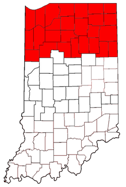
The economy of the eastern two-thirds of the region is a blend of agriculture and heavy industry, often associating the area with the Rust Belt. This region is also the most ethnically diverse part of the state. The northwest corner, including Gary and the Calumet Region (Lake and Porter counties), serves as a commuter hub for the Chicago metropolitan area and operates within the Central Time Zone.
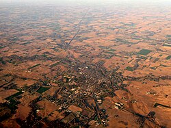
Geographically, the northwest is marked by swell and swale topography—remnants of ancient beaches where ecology shifts rapidly between marshy swales and dry swells. The Kankakee River acts as a boundary between the suburban northwest and the rest of the region. South of this river lies the eastern edge of the Grand Prairie, though native species like the American bison and prairie chicken are now extinct in the wild here.
Michiana and the Maumee Valley
The north-central area is known as Michiana, with South Bend serving as its cultural and economic heart. Other key cities include Elkhart, Mishawaka, Goshen, and Warsaw. To the east lies the Maumee Valley, centered around Fort Wayne, the state's second-largest city and a major transportation hub. This area features the Great Black Swamp's westernmost reach and several significant kettle lakes, including Lake Wawasee (the state's largest natural lake) and Lake Tippecanoe (the deepest, at over 120 feet).
Central Indiana
Central Indiana comprises 33 counties in the middle third of the state. While many residents identify this region with the Indianapolis metropolitan area, it includes other prominent cities such as Lafayette, Kokomo, Muncie, Terre Haute, and Anderson. With roughly 3.3 million residents, it is the most populous region in the state.
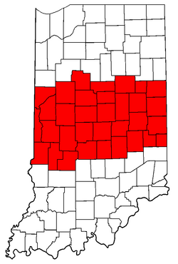
The landscape consists of low, gently rolling hills and sandstone ravines carved by retreating glaciers, particularly along Sugar Creek in Turkey Run and Shades state parks. The economy is driven by manufacturing, agriculture, and a robust education sector, featuring major institutions like Purdue University, Indiana University Indianapolis, and Ball State University.
Southern Indiana
Southern Indiana is a varied landscape of farmland, forests, and rugged hills. The region is anchored by Evansville in the southwest and the Louisville metropolitan area (Kentuckiana) in the southeast. Historically, this was the first area of the state to be settled; Vincennes, founded in 1732, is the oldest settlement and served as the first capital of the Indiana Territory.
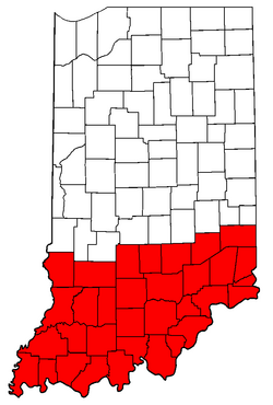
The topography is more diverse than the north, featuring the Knobs—a series of 1,000-foot hills parallel to the Ohio River. The region also hosts the 200,000-acre Hoosier National Forest and the colorful autumn foliage of Brown County. In the flood-prone bottomlands where the Wabash, White, and Ohio Rivers converge, species typically found in the Lower Mississippi and Gulf Coast regions thrive.
The Limestone Industry
The limestone geology of the south has created extensive cave systems, such as Wyandotte and Squire Boone Caverns, and one of the largest limestone quarry regions in the U.S. This high-quality stone is a hallmark of Indiana architecture, used in the Indiana Statehouse and the Pentagon, as well as the Washington National Cathedral.
Regional Summary Table
| Region | Major Cities | Key Geographic Features | Economic Drivers |
|---|---|---|---|
| Northern | South Bend, Fort Wayne, Gary | Kettle lakes, Sand dunes, Moraines | Industry, Agriculture |
| Central | Indianapolis, Lafayette, Muncie | Rolling hills, Sandstone ravines | Health, Education, Manufacturing |
| Southern | Evansville, Bloomington, Jeffersonville | The Knobs, Limestone caves, Forests | Limestone quarrying, Agriculture |
Frequently Asked Questions
What is the highest point in Indiana?
The highest point is Hoosier Hill, located in northern Wayne County, with an elevation of 1,257 feet (383 m) above sea level.
Which region of Indiana is the most populous?
Central Indiana is the most populous region, home to approximately 3.3 million people.
What is the significance of Indiana limestone?
Indiana limestone is world-renowned for its quality and has been used to construct 35 of the 50 U.S. state capitols, the Empire State Building, and the Pentagon.
What are the "Knobs" in Southern Indiana?
The Knobs are a series of hills reaching approximately 1,000 feet (300 m) that run parallel to the Ohio River in south-central Indiana.
What is the Calumet Region?
The Calumet Region refers to Lake and Porter counties in Northwest Indiana, named after the Grand Calumet and Little Calumet rivers.