Iberville Parish
Located south of Baton Rouge in the state of Louisiana, Iberville Parish (French: Paroisse d'Iberville) is a region defined by its deep historical roots and unique geography. Established in 1807, the parish serves as a vital part of the Baton Rouge metropolitan statistical area, blending rural landscapes with established municipal centers.
The parish seat is located in Plaquemine, while St. Gabriel stands as the largest municipality. With a population of 30,241 as of the 2020 census, Iberville Parish continues to be a significant cultural and administrative hub in southern Louisiana.
Key Facts
- Founded: 1807
- Named After: Pierre Le Moyne d'Iberville, founder of the French colony of Louisiana.
- Parish Seat: Plaquemine
- Largest City: St. Gabriel
- Total Area: 653 square miles (619 land / 34 water)
- 2020 Population: 30,241
History and Heritage
The parish takes its name from Pierre Le Moyne d'Iberville, the visionary who founded the French colony of Louisiana. The region's history extends far beyond the colonial era, as evidenced by significant archaeological findings. Researchers have focused heavily on the Native American burial mounds found throughout the parish, some of which are remarkably large—reaching 700 feet in length, 100 feet in width, and 6 feet in height.
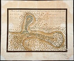
Early archaeological expeditions, such as those led by Clarence B. Moore, prioritized the study of skeletal remains to understand the previous inhabitants of the land. Additionally, historical records indicate the presence of at least two wooden forts in the area by 1779, which also represented St. Gabriel Parish.
Geography and Environment
Iberville Parish covers a total area of 653 square miles. The vast majority of this is land (619 square miles), with water accounting for 34 square miles, or approximately 5.2% of the total area. The parish is bordered by several other Louisiana parishes, including Pointe Coupee to the northwest, West Baton Rouge to the north, East Baton Rouge to the northeast, Ascension to the east, Assumption to the southeast, Iberia to the south, and St. Martin to the west.
A significant portion of the Atchafalaya National Wildlife Refuge, a protected national area, extends into the parish, highlighting the region's ecological importance.
Community Structure
The parish is organized into several types of communities:
- Cities: Plaquemine (seat) and St. Gabriel.
- Towns: Maringouin and White Castle.
- Villages: Grosse Tete and Rosedale.
- Census-Designated Places: Bayou Goula, Crescent, and Dorseyville (or Dorcyville).
- Other Unincorporated Areas: Including Alhambra, Bayou Pigeon, Bayou Sorrel, Carville, Iberville, Indian Village, Lone Star, Ramah, and Seymourville.
Demographics and Economy
The population of Iberville Parish has fluctuated over the last two centuries, peaking around the early 21st century before a slight decline. As of the 2020 census, the racial makeup was approximately 49.6% non-Hispanic white and 48.2% Black or African American, with smaller percentages of Hispanic, Asian, and Native American residents.
Economically, the parish shows a home-ownership rate of 73.4%, with a median housing value of $143,700. The median household income is $50,161, though there is a notable gender gap in median income, with males earning $54,655 compared to $30,773 for females. Approximately 27.6% of the population lives at or below the poverty line.
| Category | Detail |
|---|---|
| Total Area | 653 sq mi |
| Land Area | 619 sq mi |
| Water Area | 34 sq mi (5.2%) |
| 2020 Population | 30,241 |
| Median Household Income | $50,161 |
| Median Housing Value | $143,700 |
Government and Infrastructure
The parish is represented in the Louisiana State Senate by Republican Caleb Kleinpeter and in the state House by Republican Jeremy LaCombe. Infrastructure includes the Iberville Parish School Board and the Iberville Parish Library system, which maintains branches in Plaquemine, Bayou Pigeon, Bayou Sorrel, St. Gabriel, Grosse Tete, Maringouin, Rosedale, and White Castle.
The region also hosts critical state and military facilities. The Louisiana Department of Public Safety and Corrections operates the Elayn Hunt Correctional Center and the Louisiana Correctional Institute for Women (LCIW) in St. Gabriel; the latter houses the state's female death row. Additionally, the Gillis W. Long Center near Carville is operated by the Louisiana Army National Guard and is home to the 415th MI Battalion, the 241st MPAD, and the 61st Troop Command.
Frequently Asked Questions
Who is Iberville Parish named after?
The parish is named after Pierre Le Moyne d'Iberville, the founder of the French colony of Louisiana.
What is the largest city in Iberville Parish?
St. Gabriel is the largest municipality in the parish, although Plaquemine serves as the parish seat.
What are the notable archaeological features of the area?
The parish is known for its large and uniform Native American burial mounds, some of which measure 700 feet long and 100 feet wide.
Which national protected area is located in the parish?
A part of the Atchafalaya National Wildlife Refuge is located within Iberville Parish.
What military facilities are located in the parish?
The Gillis W. Long Center, operated by the Louisiana Army National Guard, is located on the outskirts of Carville.