Horsted Keynes: The Architectural and Spiritual History of St Giles' Church
Nestled in the heart of Sussex, Horsted Keynes is an ancient parish spanning approximately 5,000 acres of the rural, forested landscape known as the Weald. The village is situated on a sandstone ridge, characterized by Hastings Sand and clay soil. Historically, nearly 480 acres of the parish were part of the ancient Forest of Anderida, a region that heavily influenced the early construction of the village's religious sites.
The name Horsted Keynes evolved from Old English, meaning "place where horses are kept." Early records list it as Orsteda in 1121 and Horsestud in 1190. To avoid confusion with another nearby parish, it was occasionally referred to as Grethorsted or Horsted Magna. Eventually, the name Horsted de Cahaignes—later simplified to Horsted Keynes—became standard, honoring Sir William de Cahaignes, the principal landowner and associate of Robert de Mortain.
Key Facts
- Location: A rural parish in the Sussex Weald, formerly part of the Forest of Anderida.
- Ancient Roots: St Giles' Church is built on a pre-Christian pagan site within a visible stone circle.
- Unique Alignment: The church is oriented northeast–southwest to align with the summer solstice sunrise.
- Architectural Layers: The site contains elements from the Saxon, Norman, Early English Gothic, and Decorated Gothic periods.
- Landmark Feature: A tall, sharp spire that serves as a regional landmark despite the church's location in a dip.
The Sacred Site and Early Foundations
Unlike many Sussex churches that occupy high ground, St Giles' Church is situated in a deep dip to the north. This unusual placement is due to the site's history as a place of pagan worship. The current stone structure succeeded a small wattle and daub building and a subsequent wooden church crafted from local oak. The church remains within a stone circle, which likely once housed a pagan temple.
This pre-Christian origin also explains the church's atypical northeast–southwest orientation, designed to face the sunrise during the summer solstice.
From Saxon to Norman Influence
While the 1086 Domesday survey recorded the village and the landholdings of Sir William de Cahaignes and the noblewoman Wulfgifa, it did not list the church, as the survey focused on taxation. By the time of the survey, a stone Saxon church had likely replaced the timber structure, possibly under the direction of Ralph de Cahaignes. Today, remnants of this era survive in the foot of the tower and a specific doorway.
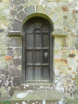
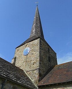
Following the Norman conquest, the church was expanded into a large cruciform (cross-shaped) design. This layout featured a nave, a chancel with an apse, and both north and south transepts, all centered around a tower topped with a landmark spire.
Architectural Evolution Through the Ages
The Gothic Transitions
Around 1220, during the Early English Gothic period, the church underwent significant modifications. The apse was replaced with a square-ended chancel and a longer floorplan. Lancet windows—tall, narrow windows with pointed arches—were installed in the east end and the south transept.
By the early 14th century (1320–1330), the Decorated Gothic style took hold. This phase introduced a wider chancel arch, new nave windows, and a pointed arch replacing the rounded west arch of the crossing. During this time, the north transept was removed and replaced by a side chapel.
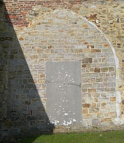
A chantry chapel dedicated to Marie de Bradehurst was also established alongside the chancel. This structure served as a schoolroom before its removal during the Victorian era, leaving behind a blocked pointed arch on the south wall.
Structural Challenges and Later Additions
The removal of the north transept and the original west arch in the 14th century caused the tower to subside and lean. To correct this, builders added buttresses and later inserted iron ties to pull the tower back toward a vertical position. The spire, confirmed to be in place by 1667, famously survived a lightning strike that dislodged 3,000 shingles.
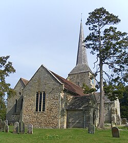
In the late 17th century, the southwest porch was reconstructed. A wider view of the church's layout reveals the integration of these various historical phases.
Victorian Restoration and Modern Preservation
In 1885, architect Spencer Slingsby Stallwood and Joseph Morris undertook a restoration costing £2,300. Their work included building a north aisle and arcade, replacing the 1714 king post roof, and removing old box pews and a western wooden gallery. It was during this period that the Saxon doorway was repositioned into the new north aisle.
Further restoration occurred between 1959 and 1961 by the firm Denman & Son, which uncovered traces of an original Norman window in the nave.
Summary of Parish and Church Characteristics
| Feature | Details |
|---|---|
| Parish Size | Approx. 5,000 acres (2,020 ha) |
| Soil Composition | Hastings Sand and clay |
| Original Orientation | Northeast–Southwest (Summer Solstice alignment) |
| Key Architectural Eras | Saxon, Norman, Early English Gothic, Decorated Gothic |
| Ecclesiastical Status | Former peculier of the Archbishop of Canterbury; Law of Sanctuary site |
Frequently Asked Questions
Why is the church oriented northeast–southwest instead of east–west?
The church was built on a pre-Christian pagan site. The original structures were aligned northeast–southwest so they would face the sunrise during the summer solstice.
What is a "peculier" in the context of this church?
For many years, the church was a peculier of the Archbishop of Canterbury, meaning it was under the direct jurisdiction of the Archbishop rather than the local Bishop of Chichester.
What caused the church tower to lean?
The subsidence was caused by the removal of the north transept and the original rounded west arch during the 14th century, which compromised the tower's stability.
What remains of the Saxon era at St Giles' Church?
The surviving Saxon elements include the foot of the tower and a doorway, which was later reset in the north aisle during the 1885 restoration.
What was the Law of Sanctuary?
The Law of Sanctuary was an ancient legal custom that provided protection to fugitives or persecuted persons who reached a designated sanctuary site; St Giles' was one of about 20 such churches in the diocese.