Great Basin: North America's Vast Endorheic Landscape
The Great Basin represents one of the most unique geographic features in North America. As the largest area of contiguous endorheic watersheds—systems where water does not flow to the ocean but instead evaporates or sinks into the ground—it creates a landscape defined by isolation and dramatic topographical shifts. Spanning nearly all of Nevada, much of Utah, and parts of California, Idaho, Oregon, Wyoming, and Baja California, this region is a complex tapestry of deserts, mountains, and ancient lake beds.
![The hydrographic Great Basin (magenta outline), distinguished from the Great Basin Desert (black), and the Basin and Range Geological Province (teal).[3]](/images/1c/9c/1c9c42073958362c2552166dbdc56dfdf60391ea86d259921410a88538f128f8.gif)
Key Facts
- Total Area: Approximately 209,162 square miles (541,730 km²).
- Hydrology: An endorheic system with no outlets to the ocean.
- Extreme Elevations: Ranges from Badwater Basin in Death Valley (-282 ft) to Mount Whitney (14,505 ft).
- Major Water Bodies: Includes the Great Salt Lake, Pyramid Lake, and Lake Tahoe.
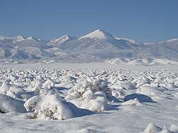
- Primary Climate: Arid, with much of the precipitation occurring as snow.
Defining the Great Basin
Because the term "Great Basin" is used in several different contexts, it is important to distinguish between its various definitions:
Hydrographic Great Basin
This is the 209,162-square-mile area that drains internally. In this region, precipitation either evaporates, sinks into underground aquifers, or flows into saline lakes. It is bounded by the Wasatch Mountains to the east, the Sierra Nevada and Cascade Ranges to the west, and the Snake River Basin to the north.
Great Basin Desert and Province
The Great Basin Desert is defined by specific plant and animal communities. Its boundaries are similar to the hydrographic basin but exclude the southern "panhandle." Meanwhile, the Great Basin Province, as defined by botanist Armen Takhtajan, extends further to include the Snake River Plain, the Colorado Plateau, and the Uinta Basin.
Great Basin Culture Area
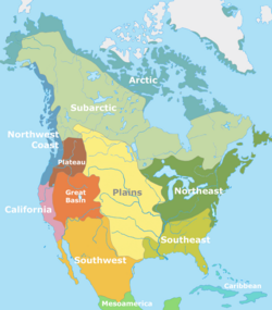
This is a cultural classification for the indigenous peoples of the region, located between the Rocky Mountains and the Sierra Nevada. This cultural area covers roughly 400,000 square miles, nearly twice the size of the hydrographic basin.
Geology and Topography
The region is characterized by the Basin and Range topography, consisting of alternating valleys and mountain ranges. Over thousands of years, sediment build-up filled the down-faulted basins between these ranges. Many of the current flat plains are actually lacustrine plains—remnants of ancient lake beds from the Pleistocene epoch.
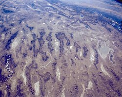
Notable historical water features include Lake Bonneville, which overflowed during the Bonneville Flood approximately 14,500 years ago, and Lake Lahontan. Today, the remnants of these massive lakes can be seen in the Great Salt Lake, Utah Lake, and the Salton Sink.
Ecology and Wildlife
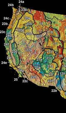
The Great Basin is not a monolith; it contains multiple deserts and ecoregions. The U.S. Environmental Protection Agency divides the area into three main ecoregions based on latitude: the Northern, Central, and Mojave Basin and Range ecoregions.
![Ecoregions as currently delineated by the Environmental Protection Agency[13] and World Wildlife Fund[14]](/images/3a/56/3a56f5b72c9d6496e82789c0cb182d8caa57656b902cc087e5619d9957bd6001.gif)
The fauna of the region is diverse, though some species face significant challenges. For instance, Pyramid Lake is home to two endangered/threatened fish species: the Cui-ui sucker fish and the Lahontan cutthroat trout.
Human History and Settlement
Indigenous Populations
Human habitation in the Great Basin dates back to at least 10,000 B.C. with the Paleo-Indians, who were nomadic hunters of bison and extinct megafauna like the mammoth. This was followed by the Great Basin Desert Archaic people (9,000 to 1,500 years ago) and later the Fremont people (1,500 to 700 years ago), who established small villages and practiced agriculture with crops like corn and squash.
European Exploration and Expansion
European exploration began during the 18th-century Spanish colonization. Later, American explorers like Jedediah Strong Smith and Peter Skene Ogden traversed the region. The mid-19th century saw significant movement through the basin via the California Trail, driven by the 1848 Gold Rush and the establishment of Mormon settlements in the Great Salt Lake Valley.
Summary of Regional Geography
| Feature | Details |
|---|---|
| Highest Point | Mount Whitney (14,505 ft) |
| Lowest Point | Badwater Basin (-282 ft) |
| Longest River | Bear River (350 mi) |
| Largest Watershed | Humboldt River (17,000 sq mi) |
| Major Cities | Salt Lake City, Reno-Sparks |
Frequently Asked Questions
What does "endorheic" mean?
An endorheic basin is a closed drainage system that retains water and allows no outflow to external bodies of water, such as oceans. Instead, water leaves the system through evaporation or seepage into the ground.
What is the difference between the Great Basin Desert and the Great Basin?
The Great Basin is a hydrographic term referring to the watershed area, while the Great Basin Desert is a biological term defined by specific plant and animal communities.
Which major cities are located in the Great Basin?
The two most populous metropolitan areas are the Reno-Sparks area in the west and the Salt Lake City centered Wasatch Front in the east.
What are some famous landmarks in the region?
The region contains several significant sites, including Death Valley National Park, Great Basin National Park, and the Great Salt Lake.
How do people travel through the Great Basin?
Major interstate highways like I-80 and I-15 traverse the region. Notable roads include US 50, known as "The Loneliest Road in America," and Nevada State Route 375, the "Extraterrestrial Highway."