Georgia and the de Soto Expedition
The journey of Hernando de Soto through the southeastern United States brought the Spanish expedition into contact with diverse and complex societies. In present-day Georgia, the expedition encountered various peoples who spoke Muskogean languages, a family of languages native to the Southeastern United States. The Spanish traversed the region during two distinct phases of their journey, each revealing different political structures and settlements.
The First Leg: Journey to Cofitachequi
During the first phase of their travels in Georgia, the expedition moved in a northeasterly direction. Their primary objective was to reach Cofitachequi, located in what is now South Carolina. Along this route, the Spanish encountered several indigenous groups, including the Capachequi, Ichisi, Ocute, and Hitchiti.
After departing from Ocute, the expedition navigated through a region described as the "Wilderness of Ocute," which corresponds to the modern-day Savannah River basin. Archaeological evidence supporting this route has been uncovered in Telfair County, Georgia, where artifacts from this first leg of the journey were discovered.
The Second Leg: The Coosa Chiefdom
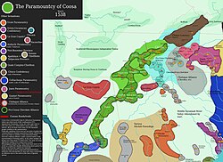
The second journey through Georgia occurred as the expedition traveled southwest from Tennessee. During this phase, the Spanish entered a vast territory controlled by the Coosa chiefdom, a powerful political entity whose influence extended across Georgia, Alabama, and Tennessee.
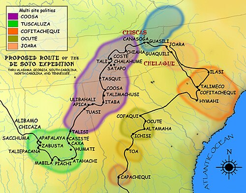
The expedition visited several key sites within the Coosa domain. The capital of the chiefdom is believed to be located at the site known as Little Egypt. Other significant locations visited or associated with this leg include the Sixtoe Mound and the Bell Field Mound Site.
As they continued their journey, the expedition encountered the Talimachusi and visited the Etowah Indian Mounds, referred to in historical records as Itaba.
Key Facts
- Language: The indigenous peoples encountered in Georgia spoke Muskogean languages.
- Route 1: Traveled northeast toward Cofitachequi (South Carolina) via the Savannah River basin.
- Route 2: Traveled southwest from Tennessee through the Coosa chiefdom.
- Coosa Influence: The Coosa chiefdom spanned territory in Georgia, Alabama, and Tennessee.
- Archaeological Sites: Key sites include Little Egypt, Sixtoe Mound, Bell Field Mound, and the Etowah Indian Mounds (Itaba).
Expedition Summary Table
| Phase | Direction | Key Regions/Chiefdoms | Notable Sites/Groups |
|---|---|---|---|
| First Leg | Northeast | Cofitachequi (SC) | Capachequi, Ichisi, Ocute, Hitchiti |
| Second Leg | Southwest | Coosa Chiefdom | Little Egypt, Sixtoe Mound, Etowah (Itaba) |
Frequently Asked Questions
Which languages were spoken by the people de Soto encountered in Georgia?
The peoples encountered during the expedition in Georgia were speakers of Muskogean languages.
What was the "Wilderness of Ocute"?
The "Wilderness of Ocute" refers to the region the expedition crossed after leaving Ocute, which is identified as the modern-day Savannah River basin.
Where was the capital of the Coosa chiefdom likely located?
The likely site of the Coosa capital is known as Little Egypt.
Which modern states did the Coosa chiefdom encompass?
The territory controlled by Coosa extended across present-day Georgia, Alabama, and Tennessee.
What is the historical name for the Etowah Indian Mounds?
The Etowah Indian Mounds were referred to as Itaba during the time of the expedition.