Georg Braun and the Civitates Orbis Terrarum
In the late 16th century, the world was becoming increasingly accessible to pilgrims, students, tradesmen, and the emerging class of tourists. This era of exploration demanded a new way of visualizing the urban landscape. Enter Georg Braun, a German topographer and cleric whose vision resulted in one of the most influential cartographic achievements of the Renaissance.
Braun is best remembered as the principal editor of the Civitates Orbis Terrarum (Atlas of Cities in the World). Published between 1572 and 1618, this monumental work was the first atlas to focus specifically on city maps, offering a comprehensive European perspective on the social, cultural, and economic life of the time.
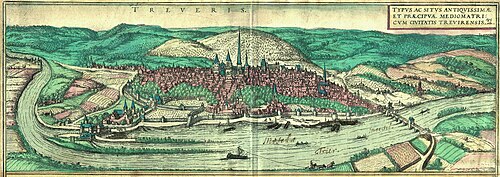
Key Facts
- Principal Work: The Civitates Orbis Terrarum, containing 546 prospects, bird's-eye views, and maps.
- Timeline: Published in six volumes between 1572 and 1617/1618.
- Role: Braun served as the principal editor, acquiring tables, hiring artists, and writing the accompanying texts.
- Legacy: Set the global standard for cartography for over a century.
- Scope: While primarily European, it included global cities such as Cairo, Casablanca, Mexico City, Cuzco, and Tunis.
The Life and Career of Georg Braun
Born and raised in Cologne, within the Electorate of Cologne in the Holy Roman Empire, Georg Braun lived a life of dual devotion. While he is celebrated today as a topographer, his primary profession was that of a Catholic cleric. He dedicated thirty-seven years of his life serving as the canon and dean at the church of St. Maria ad Gradus in Cologne.
Braun's passion for mapping led him to collaborate with other masters of the craft. He partnered closely with Frans Hogenberg, and together they created a work that complemented the Theatrum Orbis Terrarum by Abraham Ortelius. Braun's project was further inspired by Sebastian Münster's Cosmographia.
The Civitates Orbis Terrarum: A Cartographic Milestone
The Civitates Orbis Terrarum was more than just a collection of maps; it was a visual encyclopedia of urbanity. The atlas featured 546 views, including detailed street plans for major hubs like Frankfurt and Venice. Braun's editorial eye captured the essence of the era, noting, for example, that London was "famed among many people for its commerce."
Production and Collaboration
The creation of the six-volume set required a massive collaborative effort. Braun managed the project, but the visual execution relied on several skilled artists and cartographers:
- Frans Hogenberg: Created the tables for Volumes I through IV.
- Simon van den Neuwel: Produced the tables for Volumes V and VI.
- Other Contributors: Joris Hoefnagel, Jacob Hoefnagel, Daniel Freese, and Heinrich Rantzau.
- Referenced Works: The atlas utilized existing works by Jacob van Deventer, Sebastian Münster, and Johannes Stumpf.
Global Reach
Although the focus was heavily European, the atlas demonstrated a growing global awareness. Volume I included depictions of Mexico City, Cuzco, Cairo, and Casablanca, while Volume II featured Tunis.
| Feature | Details |
|---|---|
| Total Views/Maps | 546 |
| Publication Period | 1572–1618 |
| Number of Volumes | 6 |
| Primary Editor | Georg Braun |
| Key Collaborator | Frans Hogenberg |
| Notable City Plans | Venice and Frankfurt |
Final Years and Legacy
Georg Braun remained dedicated to his work until the very end. He was the sole survivor of the original production team to witness the publication of the final volume (Volume VI) in 1617. He passed away in his hometown of Cologne on March 10, 1622, at the age of 81.
Frequently Asked Questions
What was the Civitates Orbis Terrarum?
It was the first atlas to specifically feature city maps, containing 546 bird's-eye views and prospects of cities worldwide, published between 1572 and 1618.
What was Georg Braun's primary profession?
While known for his cartographic work, Braun was primarily a Catholic cleric, serving as a canon and dean at St. Maria ad Gradus in Cologne for 37 years.
Who were the main artists involved in the atlas?
The primary artist for the first four volumes was Frans Hogenberg, while Simon van den Neuwel handled the final two volumes. Other contributors included Joris and Jacob Hoefnagel.
Did the atlas include cities outside of Europe?
Yes. Despite its European focus, it included maps of Cairo, Casablanca, Tunis, Mexico City, and Cuzco.
How did the atlas influence future cartography?
The publication set new standards for the depiction of urban areas and cartographic layout that persisted for over 100 years.