Geophysics: The Science of Earth's Physical Properties and Planetary Systems
Geophysics is a physical science that utilizes quantitative and observational methods to study the processes and properties of the Earth and its surrounding space environment. By integrating theory, observation, and experiment, geophysicists investigate the planet's shape, its gravitational, magnetic, and electromagnetic fields, and the internal dynamics that drive surface phenomena like volcanism and tectonics.
Beyond the solid Earth, geophysics adopts a planetary perspective, encompassing the oceans, atmosphere, cryosphere, ionosphere, and magnetosphere. This broad framework allows scientists to understand solar-terrestrial interactions and compare Earth's processes with those occurring on the Moon and other planets.
Key Facts
- Internal Heat: Approximately 80% of Earth's internal heat is generated by radioactive decay.
- Magnetic Reversals: Earth's magnetic polarity reverses at random intervals, averaging every 440,000 to 1 million years.
- Core Composition: The Earth's core consists of an alloy of iron and other minerals, inferred from mass and moment of inertia data.
- Electric Field: A downward electric field near the surface averages 120 volts per meter.
- Tidal Cycles: The Moon and Sun create two high and two low tides every lunar day (24 hours and 50 minutes).
Physical Phenomena of the Earth
Gravity and Tides
The gravitational interaction between the Earth, Moon, and Sun governs the planet's tidal patterns. This results in a cycle where high tides and low tides occur every 12 hours and 25 minutes.
Electricity and Electromagnetism
Earth maintains a global electrical circuit with a current of approximately 1800 amperes. This is driven by the ionization of the atmosphere by galactic cosmic rays, which gives the atmosphere a net positive charge relative to the solid Earth. This current flows downward from the ionosphere and returns upward through thunderstorms, manifesting as lightning and sprites.
Magnetism and Polarity
The Earth's magnetic field behaves similarly to a tilted dipole. While the geomagnetic pole generally remains near the geographic pole, the field undergoes geomagnetic secular variation (changes over time) and periodic polarity reversals. In the last 83 million years, there have been 184 polarity intervals. The most recent brief complete reversal, the Laschamp event, occurred 41,000 years ago.
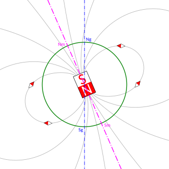
![Computer simulation of the Earth's magnetic field in a period of normal polarity between reversals[22]](/images/39/7b/397ba5f4e165b63acd1fe4ededad492bc85708176a80958f6f68d19f8eddafb3.gif)
These reversals are recorded in volcanic rocks and appear as linear magnetic anomaly stripes on the seafloor. These stripes provide critical evidence for seafloor spreading and plate tectonics, forming the basis of magnetostratigraphy—the correlation of magnetic reversals to construct geologic time scales.
Radioactivity and Internal Heat
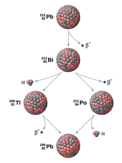
The Earth's internal heat, which powers plate tectonics and the geodynamo, is primarily produced by the decay of isotopes: potassium-40, uranium-238, uranium-235, and thorium-232. This process is also the foundation of radiometric dating, the primary method for establishing absolute time scales in geochronology.
Earth's Internal Structure and Dynamics
Composition and Density
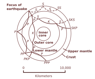
Scientists infer the interior's composition by combining seismology, surface heat flow, and mineral physics with the Earth's mass and moment of inertia. The Earth's mean specific gravity (5.515) is significantly higher than surface rocks (2.7–3.3), indicating a much denser interior. While the Adams–Williamson equation helps calculate the effect of pressure-induced compression, pressure alone cannot explain this density; thus, the core is known to be an iron-mineral alloy.
Mantle and Core Dynamics
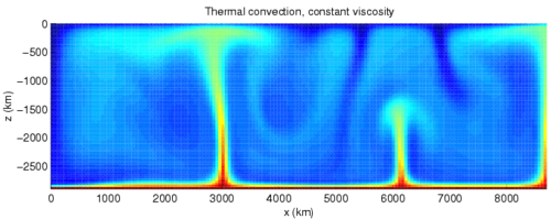
Thermal convection in the mantle, often characterized by mantle plumes, drives the movement of tectonic plates.
The Magnetosphere
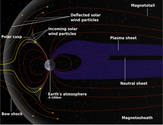
The magnetosphere is the region of space surrounding Earth where the planetary magnetic field dominates the behavior of charged particles, shielding the planet from the solar wind.
Geophysical Methods and Tools
Geodesy and Gravity Mapping
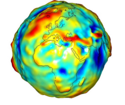
Geodesy is the science of measuring Earth's geometric shape and orientation in space. Gravity measurements are essential for relating surface measurements to a reference coordinate system. Modern tools include gravimeters and satellite-based radar altimetry to define the geoid.
The Gravity Recovery and Climate Experiment (GRACE), launched by NASA in 2002, uses twin satellites to map gravity variations. These variations reveal changes in groundwater depletion, ice sheet melting, and ocean currents.
Seismology
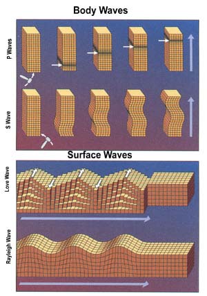
Seismology studies vibrations and waves traveling through the Earth. By analyzing body waves and surface waves, geophysicists can map the interior boundaries of the planet.
Data Integration
Modern geophysics relies on a suite of technologies, including Global Positioning Systems (GPS), Geographical Information Systems (GIS), remote sensing, and advanced signal processing to analyze both natural and instrumented records.
History of Geophysics
Ancient Contributions
The roots of geophysics date back to antiquity. In 132 AD, Zhang Heng invented the seismoscope, a device that used a bronze ball and dragon-toad mechanism to determine the direction of an earthquake.

The Birth of Modern Science
The 17th century brought a shift toward experimental science. In 1600, William Gilbert published De Magnete, where he used a versorium (a small compass needle) to demonstrate that the Earth itself acts as a giant magnet, explaining why compasses point north.
Summary of Geophysical Properties
| Property | Value/Detail | Significance |
|---|---|---|
| Mean Specific Gravity | 5.515 | Indicates a dense metallic core |
| Surface Electric Field | ~120 V/m | Result of atmospheric ionization |
| Global Circuit Current | ~1800 Amperes | Flows between ionosphere and Earth |
| Internal Heat Source | 80% Radioactive Decay | Powers plate tectonics and geodynamo |
| Magnetic Polarity Cycle | 440k to 1M years (avg) | Used for magnetostratigraphy |
Frequently Asked Questions
What is the difference between the geographic pole and the geomagnetic pole?
The geographic pole is the fixed axis upon which the Earth rotates, while the geomagnetic pole is the point where the Earth's magnetic field is vertical. The magnetic pole is not fixed and shifts over time due to geomagnetic secular variation.
How do geophysicists know the core is made of iron?
This is inferred by comparing the Earth's mean specific gravity (5.515) with the lower density of surface rocks (2.7–3.3). Since pressure alone (calculated via the Adams–Williamson equation) cannot account for this difference, a dense metallic alloy, primarily iron, must exist at the center.
What are magnetic anomaly stripes?
These are parallel linear patterns of magnetic polarity recorded in the seafloor. They occur as new magma rises and cools, locking in the current magnetic polarity. These stripes provide quantitative evidence for seafloor spreading.
How does radioactive decay help in dating rocks?
Certain isotopes (like Uranium-238 or Potassium-40) decay at constant, known rates. By measuring the ratio of parent isotopes to daughter products in a sample, scientists can determine the absolute age of the rock through radiometric dating.
What is the purpose of the GRACE satellites?
The Gravity Recovery and Climate Experiment (GRACE) satellites measure the precise distance between each other to map variations in Earth's gravity field. This allows scientists to track changes in ice sheets, glaciers, and groundwater levels.