Foreland Basins: Mechanics, Types, and Global Examples
In the study of Earth's crust, a foreland basin is a structural depression that develops adjacent and parallel to a mountain belt. These basins are fundamental to understanding how the planet's surface reshapes itself during massive tectonic events. Unlike rift basins, which are created by the stretching of the lithosphere, foreland basins are formed by the weight of the mountains themselves.
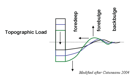
The primary driver of this formation is lithospheric flexure—the process where the immense mass of a mountain belt, created by crustal thickening, causes the underlying lithosphere (the rigid outer layer of the Earth) to bend downward. This bending creates accommodation space, which is then filled with thick layers of sediment eroded from the neighboring mountains. The depth and width of these basins depend on the characteristics of the mountain belt and the flexural rigidity of the lithosphere.
Key Facts
- Formation: Caused by lithospheric flexure due to the loading of an adjacent mountain belt.
- Sedimentation: Filled by eroded material from the orogen, thinning as distance from the mountains increases.
- Thermal State: Generally hypothermal (cooler than normal) with low heat flow.
- Fluid Dynamics: Act as major conduits for the long-range migration of brines, minerals, and hydrocarbons.
- Contrast: While rift basins form via extension, foreland basins form via loading and downflexure.
Types of Foreland Basins
Geologists categorize foreland basins based on their position relative to the plate collision or subduction zone:
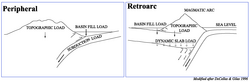
Peripheral (Pro) Foreland Basins
These occur on the plate that is being subducted or underthrust during a collision, effectively sitting on the outer arc of the orogen. Notable examples include the Ganges Basin in Asia and the North Alpine Foreland Basin in Europe.
Retroarc Foreland Basins
These develop on the opposite side of the mountain belt from the subduction zone. Examples include the Andean basins in South America and the Rocky Mountain Basins of North America.
The Foreland Basin System
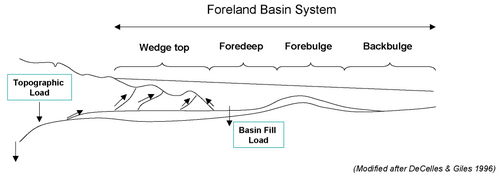
A foreland basin system is defined by its relationship to the fold-thrust belt. Its longitudinal dimension is typically equal to the length of that belt. The system evolves as a moving load system, where the deflection of the crust moves like a wave through the foreland plate. This results in an asymmetrical low near the load and a broader uplifted area known as the forebulge.
Lithospheric Behavior and Strength
The rheology (how materials flow and deform) of the lithosphere differs significantly between the basin and the mountain range. The foreland basin typically mirrors a rifted continental margin, featuring three brittle layers above three ductile layers. In contrast, the lithosphere beneath the mountain range is much hotter and becomes almost entirely ductile, except for a thin brittle layer (approximately 6 km) near the surface.
Fluid Migration and Hydrocarbons
Foreland basins play a critical role in the movement of subsurface fluids. As sediments are buried and compacted, roughly one-third of the fluids in the pores are expelled. These fluids, including brines and petroleum, migrate in response to deformation and potential energy.
- Brine Migration: Evidence of long-range migration includes the presence of ore bodies deposited from metal-bearing brines and the correlation of petroleum to distant source rocks.
- Hydrocarbon Flow: Petroleum moves due to buoyancy, capillary effects, and hydrodynamic forces. Generally, migration flows away from the mountain belt toward the cratonic interior, with natural gas often found closer to the orogen and oil found further away.
Global Examples of Foreland Basins
| Region | Basin Name | Type/Characteristic | Key Detail |
|---|---|---|---|
| Asia | Ganges Basin | Pro-foreland | Sediment succession > 12 km thick |
| Asia | Southern Junggar | Retro-foreland | Mesozoic sediment > 8,000 m thick |
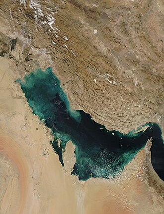
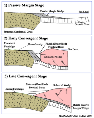
| Middle East | Persian Gulf | Foreland | Underfilled stage; covers Iraq and Kuwait |
| Europe | North Alpine (Molasse) | Peripheral | Formed 65.5–2.6 Ma |
| Europe | Po Basin | Retro/Pro-foreland | Complex extensional and compressional history |
| North America | Western Interior Basin | Foreland | Cretaceous age; contains Mancos Shale |
| South America | Andean Basins | Foreland | Includes Llanos and Neuquén basins |
Frequently Asked Questions
What is the main difference between a foreland basin and a rift basin?
The primary difference is how accommodation space is created. Foreland basins are formed by loading and the downward bending (flexure) of the lithosphere, whereas rift basins are created by the stretching and extension of the lithosphere.
Why are foreland basins described as hypothermal?
They are considered hypothermal because they exhibit lower-than-normal geothermal gradients and heat flow, with average values between 1 and 2 HFU (40–90 mWm). This is often attributed to rapid subsidence.
How does the lithosphere behave under a mountain belt?
Due to significantly higher temperatures, the lithosphere beneath an orogenic belt becomes almost entirely ductile, except for a very thin brittle layer near the surface and potentially in the uppermost mantle.
In what direction do hydrocarbons typically migrate in these basins?
Hydrocarbons generally migrate away from the orogenic belt and toward the cratonic interior. Typically, natural gas is located closer to the mountains, while oil is found further away.