Flat River: A Winding Waterway of Michigan
The Flat River is a significant tributary of the Grand River located in the western region of Michigan. Known in the Ottawa language as Quabahquasha, meaning "Winding Stream," this river carves a path through the landscape, serving as a vital natural resource and a piece of regional history for centuries.
The river begins its journey as the outflow of First Lake, which is the final link in a chain of connected bodies of water known as the Six Lakes. Located in Belvidere Township, west of Edmore in Montcalm County, the river descends from an elevation of 915 feet, winding its way south and slightly west across three different counties before reaching its destination.
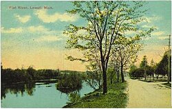
Key Facts
- Total Length: 70 miles (110 km).
- Basin Size: 560 square miles (1,500 km).
- Course: Flows through Montcalm, Ionia, and Kent counties.
- Major Cities: Passes through Greenville, Belding, and Lowell.
- Mouth: Empties into the Grand River in Lowell.
- Average Discharge: Estimated at 530.62 cubic feet per second.
Geography and Physical Characteristics
The Flat River's journey is defined by a steady decline in elevation, starting at 915 feet at First Lake and ending at 617 feet where it joins the Grand River. Its basin covers 560 square miles, draining a significant portion of the western Michigan interior.
| Feature | Detail |
|---|---|
| Source | First Lake, Montcalm County |
| Mouth | Grand River, Lowell |
| Length | 70 miles |
| Average Discharge | 530.62 cu ft/s |
| Counties Traversed | Montcalm, Ionia, Kent |
Cultural and Historical Significance
Long before modern development, the Flat River served as a critical water route and a primary fishing source for the Grand River Band of Ottawa during the 18th and 19th centuries. The river's winding nature provided both sustenance and transportation for the indigenous populations of the region.
In addition to its indigenous history, the river is associated with local folklore, being the namesake river in the song "Sad Ballad of Jack Haggerty," also referred to as "Flat River Girl."
Historic Covered Bridges
The river is noted for its historic covered bridges, which are traditional timber-framed bridges with a roof and siding to protect the structural beams from the elements. Two such bridges are prominent in the area:
- Fallasburg Bridge: Located in Fallasburg County Park within Vergennes Township, Kent County.
- Whites Bridge: Located in northwest Keene Township, Ionia County. This bridge was the oldest of its kind in Michigan until it was destroyed by an arson fire on July 7, 2013. Efforts to rebuild the bridge have since been pursued through fundraising.
River Infrastructure
To manage water flow and support local industry, five dams have been constructed along the course of the Flat River. These are located at:
- Greenville
- Belding
- Whites Bridge
- Burroughs
- Lowell
Frequently Asked Questions
Where does the Flat River begin?
The Flat River originates as the outflow of First Lake in Belvidere Township, Montcalm County, which is part of a chain of lakes known as the Six Lakes.
Which river does the Flat River flow into?
The Flat River is a tributary that flows into the Grand River in the city of Lowell.
What is the meaning of the river's Ottawa name?
In the Ottawa language, the river is called Quabahquasha, which translates to "Winding Stream."
What happened to the Whites Bridge?
Whites Bridge, which was the oldest covered bridge of its kind in Michigan, was destroyed by an arson fire on July 7, 2013.
How many dams are located on the Flat River?
There are five dams along the river, located at Greenville, Belding, Whites Bridge, Burroughs, and Lowell.