Eunpyeong: A Comprehensive Overview of Seoul's Northwestern District
Located in the northwestern reaches of Seoul, South Korea, Eunpyeong-gu (Eunpyeong District) serves as a vital residential and cultural hub within the Sudogwon region. As one of the 25 autonomous districts that comprise the capital city, Eunpyeong offers a unique blend of urban connectivity and traditional charm, bordering the city of Goyang to the west and several key Seoul districts to the south and east.
Key Facts
- Location: Northwestern Seoul, bordering Goyang, Mapo, Seodaemun, and Jongno.
- Total Area: 29.7 km² (11.5 sq mi).
- Population: 450,583 (as of 2010 census).
- Administrative Divisions: 16 dong (neighborhoods).
- Major Transit: Served by Seoul Subway Lines 3 and 6.
- Current Mayor: Kim Mi-kyung (Democratic Party).
Geography and Administration
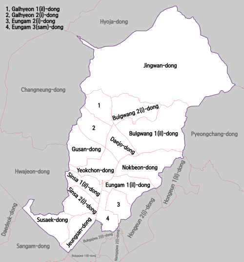
Eunpyeong-gu is characterized by its diverse landscape and organized administrative structure. The district is divided into 16 dong, which are the smallest administrative neighborhood units in South Korea. This structured division allows for efficient local governance and community management.
Administrative Neighborhoods (Dong)
The district is composed of the following 16 administrative divisions:
- Bulgwang-dong
- Daejo-dong
- Eungam-dong
- Galhyeon-dong
- Gusan-dong
- Jeungsan-dong
- Jingwan-dong
- Nokbeon-dong
- Sinsa-dong
- Susaek-dong
- Yeokchon-dong
Culture and Landmarks
Eunpyeong is home to several notable cultural and natural sites that provide a respite from the dense urban environment. One of the most significant attractions is the Eunpyeong Hanok Village located in Jingwan-dong, which showcases traditional Korean architecture. Other points of interest include the Savina Museum and the Institute for the Translation of Korean Classics.
The district's natural landscape is further enhanced by local waterways, such as the Bulgwangcheon and Gupabalcheon streams, which provide green corridors for residents.
Transportation and Connectivity
Efficient public transit is a cornerstone of life in Eunpyeong, primarily facilitated by the Seoul Metropolitan Subway system. The district is well-connected to the rest of the capital through two major lines:
Seoul Subway Line 3
Line 3 provides essential connectivity, running through key stations such as Gupabal, Yeonsinnae, Bulgwang, and Nokbeon, linking Eunpyeong to Deogyang-gu in Goyang and Seodaemun-gu.
Seoul Subway Line 6
Line 6 offers extensive service within the district, passing through stations including Susaek, Jeungsan, Saejeol, Eungam, Yeokchon, Bulgwang, Dokbawi, Yeonsinnae, and Gusan. Notably, the segment between Eungam and Eungam via Bulgwang and Yeonsinnae operates as a single direction zone.
District Summary Data
| Category | Details |
|---|---|
| Country | South Korea |
| Region | Sudogwon (Seoul Special City) |
| Coordinates | 37°36′9.71″N 126°55′44.80″E |
| Population Density | 15,200/km² |
| Time Zone | UTC+9 (Korea Standard Time) |
| Postal Code Range | 03300 – 03599 |
Frequently Asked Questions
What are the boundaries of Eunpyeong-gu?
Eunpyeong is located in northwestern Seoul. It borders the city of Goyang in Gyeonggi Province to the west, Mapo District to the southwest, Seodaemun District to the south, and Jongno District to the east.
How many administrative neighborhoods are in Eunpyeong?
Eunpyeong-gu is divided into 16 administrative dong.
Which subway lines serve the district?
The district is served by Seoul Subway Line 3 and Seoul Subway Line 6.
What is a notable cultural site in Eunpyeong?
The Eunpyeong Hanok Village in Jingwan-dong is a prominent cultural landmark featuring traditional Korean housing styles.
Who is the current leader of Eunpyeong-gu?
As of the records following the July 2018 election, Kim Mi-kyung of the Democratic Party serves as the Mayor.