Crary's Contributions to Polar Science and Geophysics
The advancement of our understanding of the Earth's polar regions owes much to the dedicated leadership and scientific rigor of Crary. Through decades of fieldwork in the most extreme environments on the planet, Crary played a pivotal role in establishing the infrastructure and data sets that define modern polar research.
Key Facts
- Served as Chief Scientist for Arctic T3 at Fletcher's Ice Island from 1952 to 1955.
- Held leadership roles during the International Geophysical Year (IGY) in 1955 and 1957.
- Led multiple critical geophysical traverses across the Ross Ice Shelf and toward the South Pole.
- Directed the Division of Environmental Sciences at the National Science Foundation (NSF) from 1969 to 1978.
- Collaborated on Project Mogul, utilizing meteorological balloons to study upper atmosphere sound waves.
Arctic and Antarctic Leadership
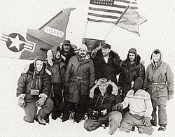
Crary's early career was marked by significant contributions to Arctic research. Between 1952 and 1955, he served as the Chief Scientist for Arctic T3, based at Fletcher's Ice Island. This period of research provided essential data on the Arctic environment during a formative era of polar science.
His influence expanded globally during the International Geophysical Year (IGY), a coordinated global effort to study Earth's geophysics. In 1955, Crary established the United States Geological Headquarters for the IGY, and by 1957, he had risen to the position of Deputy Leader of United States science for the initiative.
Antarctic Expeditions and Traverses
Crary is perhaps best known for his leadership of geophysical traverses—systematic journeys across a region to take scientific measurements. From 1957 to 1958, he led the U.S. seismic traverse of the Ross Ice Shelf, a massive floating slab of ice. This was followed by a 1958–1959 traverse from Little America V, moving up the Skelton Glacier to the Victoria Land plateau and west along the 78th parallel.
His field leadership culminated in the 1960–1961 expedition, where he led a geophysical traverse from McMurdo Station via the Skelton Glacier all the way to the South Pole.
Institutional Impact and Administration
Beyond the field, Crary shaped the administration of American science. He served as the Chief Scientist for the United States Antarctic Research Program from 1960 to 1968. His expertise later led him to the National Science Foundation, where he served as Deputy Director and eventually Director of the Division of Environmental Sciences between 1969 and 1978.
Additionally, Crary was a member of the Advisory Committee on Antarctic Names (ACAN) from 1961 to 1976, serving as the committee's Chairman from 1974 to 1976.
Collaborations and Specialized Projects
Throughout his career, Crary worked alongside distinguished figures and institutions, including Dr. Maurice Ewing of Columbia University and the Woods Hole Oceanographic Institution.
One of his most unique assignments was assisting Dr. James Peoples at Project Mogul. Serving as the Field Operations Director, Crary utilized meteorological balloons to experiment with equipment designed to collect and transmit sound waves in the upper atmosphere. This project is often cited in historical discussions regarding the Roswell incident.
| Period | Role / Project | Focus Area |
|---|---|---|
| 1952–1955 | Chief Scientist, Arctic T3 | Fletcher's Ice Island |
| 1955–1957 | IGY Leadership | US Geological Headquarters / Deputy Leader |
| 1957–1961 | Traverse Leader | Ross Ice Shelf, Skelton Glacier, South Pole |
| 1960–1968 | Chief Scientist | US Antarctic Research Program |
| 1969–1978 | Director | NSF Division of Environmental Sciences |
Frequently Asked Questions
What was Crary's role in the International Geophysical Year?
Crary established the United States Geological Headquarters for the IGY in 1955 and served as the Deputy Leader of United States science during the event in 1957.
Which Antarctic regions did Crary explore?
He led traverses across the Ross Ice Shelf, the Skelton Glacier, the Victoria Land plateau, and conducted a journey from McMurdo Station to the South Pole.
What was Project Mogul?
Project Mogul was an experiment using meteorological balloons to collect and transmit sound waves in the upper atmosphere, where Crary served as the Field Operations Director.
How did Crary contribute to the National Science Foundation?
He served as the Deputy Director and then the Director of the Division of Environmental Sciences from 1969 to 1978.
What is a geophysical traverse?
A geophysical traverse is a scientific journey across a specific geographic area, such as a glacier or ice shelf, used to take systematic measurements of the Earth's physical properties.