Coningsby: Geography and Climate of a Historic Lincolnshire Town
Nestled in the heart of Lincolnshire, Coningsby is a town with deep linguistic roots and a unique geographical position. Its name is derived from the Old Norse words konungr, meaning "King," and by, meaning "settlement," effectively translating to the "settlement of the King." This heritage reflects the town's long history within the English landscape.
Geography and Location
Coningsby is strategically positioned approximately 7 miles (11 km) south of Horncastle. It is accessible via the A153 road, which connects Horncastle to Sleaford, and is also traversed by the B1192 road running between Kirton and Woodhall Spa. The town sits in a diverse landscape, flanked by the Lincolnshire Wolds (a range of hills) to the east and the Fens (low-lying marshland) to the west.
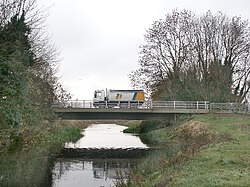
At its western boundary, the town is separated from the neighboring village of Tattershall by the River Bain.
Transport History
The town's infrastructure once included the Kirkstead and Little Steeping Railway. This line opened on 1 July 1913 and served the area for several decades before closing on 5 July 1970. While the Coningsby railway station has since been demolished, the station master's house remains as a physical reminder of this era.
Climate and Weather Extremes
Coningsby has gained significant meteorological attention for recording some of the most extreme temperatures in the United Kingdom. On 19 July 2022, the town recorded a temperature of 40.3 °C (104.5 °F), marking the highest temperature ever recorded in the UK.
Conversely, the town also experiences significant cold. The lowest temperature recorded since 1978 was −13.3 °C (8.1 °F), which occurred on 11 February 2012.
Key Facts
- Etymology: Name comes from Old Norse for "settlement of the King."
- UK Record: Site of the UK's highest recorded temperature (40.3 °C in July 2022).
- Geography: Located between the Lincolnshire Wolds and the Fens.
- Waterways: Bordered to the west by the River Bain.
- Railway: The Kirkstead and Little Steeping Railway operated here from 1913 to 1970.
Climate Data Summary (1991–2020 Normals)
The following table provides a detailed look at the climate data recorded at RAF Coningsby, situated 6 meters (20 ft) above mean sea level (amsl).
| Metric | Coldest Month (Jan) | Warmest Month (Jul) | Annual Average/Record |
|---|---|---|---|
| Mean Daily Maximum | 7.3 °C (45.1 °F) | 22.2 °C (72.0 °F) | 14.4 °C (57.9 °F) |
| Daily Mean | 4.3 °C (39.7 °F) | 17.3 °C (63.1 °F) | 10.3 °C (50.5 °F) |
| Mean Daily Minimum | 1.2 °C (34.2 °F) | 12.4 °C (54.3 °F) | 6.3 °C (43.3 °F) |
| Record High | 15.2 °C (59.4 °F) | 40.3 °C (104.5 °F) | 40.3 °C (104.5 °F) |
| Record Low | −13.2 °C (8.2 °F) | 4.5 °C (40.1 °F) | −13.3 °C (8.1 °F) |
| Avg Precipitation | 47.6 mm (1.87 in) | 54.8 mm (2.16 in) | 594.1 mm (23.39 in) |
Frequently Asked Questions
What does the name Coningsby mean?
The name is derived from Old Norse, where "konungr" means King and "by" means settlement, meaning the town is the "settlement of the King."
What is the record high temperature in Coningsby?
The record high is 40.3 °C (104.5 °F), recorded on 19 July 2022, which is the highest temperature ever recorded in the United Kingdom.
What geographical features surround the town?
Coningsby is situated with the Lincolnshire Wolds to the east and the Fens to the west, and it is separated from Tattershall by the River Bain.
Was there ever a railway in Coningsby?
Yes, the Kirkstead and Little Steeping Railway operated in the town from 1 July 1913 until it closed on 5 July 1970. Only the station master's house remains today.
What is the lowest temperature ever recorded in the town since 1978?
The lowest recorded temperature since 1978 was −13.3 °C (8.1 °F), which occurred on 11 February 2012.