Understanding the Colorado State Highway System
Navigating the diverse landscapes of Colorado requires a solid understanding of the roads that connect its bustling cities to its remote wilderness. The Colorado State Highway System is a vast network of public paved roads that serves as the backbone of the state's transportation infrastructure. Managed and maintained by the Colorado Department of Transportation (CDOT), these roads range from high-speed rural corridors to complex urban expressways.
While many travelers are familiar with the massive Interstate and U.S. Highway networks, the state-specific highways—often abbreviated as SH—provide essential connectivity throughout the region. From the longest stretches of highway to tiny connector routes, the system is a carefully managed web of infrastructure funded by the people of Colorado.
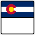
Sample highway shield used today for numbered highways
The Role of the Colorado Department of Transportation (CDOT)
The Colorado Department of Transportation, commonly known as CDOT, is the primary agency responsible for the state's entire road network. This responsibility includes the maintenance and oversight of Interstate Highways, United States Numbered Highways, and the specific numbered state highways that exist within Colorado's borders.
To keep these roads safe and functional, CDOT utilizes state funds derived from two primary sources: state and federal gas taxes, as well as a portion of vehicle registration fees. This funding ensures that the thousands of miles of pavement can withstand the varied weather conditions found across the state.
System Structure and Numbering
The Colorado state highway system is distinct from the national systems managed by the American Association of State Highway and Transportation Officials (AASHTO). While Interstates and U.S. Highways follow national standards, Colorado's state highways are managed independently by the state.
Highway Designations
The numbering of state highways follows a specific logic. Numbers begin at 1 and increase sequentially, with one major rule: a state highway number will not duplicate a number already assigned to a U.S. Highway or an Interstate Highway within the state.
Historically, the system has undergone significant changes. In 1953, many highways were decommissioned or saw a reduction in mileage. Furthermore, prior to the 1968 Colorado state highway renumbering, many routes were cosigned—meaning they shared a designation with a U.S. or Interstate highway. Today, when a state highway runs concurrently (alongside) a U.S. or Interstate route, CDOT typically does not recognize the state highway's mileage; instead, the mileage is attributed to the primary Interstate or U.S. route. In some cases, these concurrent state routes may even go unsigned.
Visual Identification
You can easily identify a Colorado state highway by its unique route marker. Unlike the consistent markers used in neighboring states, Colorado uses a distinctive design: the top half of the shield features the Colorado state flag, while the bottom half displays the highway number.
Road Characteristics and Scale
The physical nature of Colorado's highways varies significantly depending on the geography. In rural areas, most state highways are two-lane roads with speed limits reaching up to 65 miles per hour. However, as these roads enter served communities, speed limits can drop to 30 miles per hour for safety. In major metropolitan areas like Denver and Colorado Springs, state highways can transform into massive six-to-eight lane expressways.
The scale of the system is impressive, covering approximately 3,135 miles of road. This figure represents the state highway mileage after subtracting the miles belonging to the Interstate and U.S. Highway systems from the total 9,100 miles of the state's highway network.
Extreme Lengths in the System
The system contains both massive arteries and incredibly short connectors:
- The Longest Route: State Highway 14, which spans nearly 237 miles (381 km) between Muddy Pass and Sterling.
- The Shortest Route: State Highway 110, which covers a mere 0.186 miles (0.299 km).
Key Facts
- Managing Agency: Colorado Department of Transportation (CDOT).
- Total Highway Mileage: Approximately 9,100 miles (including Interstates and U.S. Highways).
- State Highway Mileage: Approximately 3,135 miles.
- Funding Sources: State and federal gas taxes, and vehicle registration fees.
- Route Marker Design: Features the Colorado state flag on the top half and the number on the bottom.
- Longest State Highway: SH 14 (approx. 237 miles).
- Shortest State Highway: SH 110 (approx. 0.186 miles).
Summary of Highway Types
| System Type | Abbreviation | Management/Standard |
|---|---|---|
| Interstate | I-X | National/AASHTO |
| U.S. Highway | US X | National/AASHTO |
| State Highway | SH X | Colorado State (CDOT) |
Frequently Asked Questions
How are Colorado state highways funded?
The maintenance and construction of state highways are funded through state and federal gas taxes, as well as a portion of the fees collected from vehicle registrations.
What makes a Colorado state highway sign unique?
Colorado state highway markers are unique because they feature the state flag on the top half of the shield and the specific highway number on the bottom half.
What happens when a state highway and an Interstate share the same road?
This is known as a concurrent route. In these instances, CDOT generally uses the mileage of the Interstate or U.S. Highway for official records, and the state highway designation may sometimes be left unsigned.
Are all state highways two lanes?
No. While most state highways in rural areas are two-lane roads, they can become six-to-eight lane expressways in urban centers like Denver and Colorado Springs.
How does the numbering of state highways work?
State highways are numbered starting from 1 and increasing upward. However, they will not use a number that is already assigned to a U.S. Highway or an Interstate Highway within the state.