Altamaha River: Georgia's Pristine Waterway and Ecological Treasure
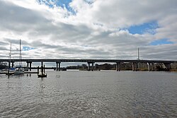
The Altamaha River is one of the most significant river systems in the United States, serving as a vital artery for the state of Georgia. Flowing generally eastward for 137 miles (220 km), it begins at the confluence of the Oconee and Ocmulgee Rivers and journeys toward the Atlantic Ocean, eventually emptying into the sea near Brunswick. Renowned for its lack of dams on the main stem, the Altamaha remains one of the most natural river systems on the Atlantic coast.
With a massive drainage basin covering approximately 14,000 square miles (36,000 km), the Altamaha is a powerhouse of freshwater discharge. When including its longest tributary, the Ocmulgee, the system reaches a total length of 470 miles (760 km), making it the seventh-longest river entirely contained within a single U.S. state.
Key Facts
- Source: Confluence of the Oconee and Ocmulgee Rivers near Lumber City, Georgia.
- Mouth: Altamaha Sound, Atlantic Ocean.
- Length: 137 miles (main stem); 470 miles (including Ocmulgee).
- Basin Size: 14,000 square miles.
- Conservation Status: Designated as a bioreserve in 1991 and one of the "Last Great Places" by The Nature Conservancy.
- Unique Feature: One of the largest intact, undegraded estuaries on the Atlantic coast.
Course and Geography
The river originates near Lumber City, initially forming the border between Montgomery and Jeff Davis Counties. As it winds eastward, it traverses areas of low population density, passing through a series of wildlife management areas and natural landmarks.
Upper and Middle Reach
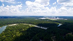
In its early miles, the river's southern floodplain is occupied by the Bullard Creek Wildlife Management Area. Further downstream, the Ohoopee River joins the Altamaha in Tattnall County. This area is home to the Big Hammock Natural Area, a National Natural Landmark celebrated for its biodiversity and rare plants, such as the Georgia plume.
As the river continues, it marks the boundary between Long and Wayne Counties, passing through the Griffin Ridge Wildlife Management Area and the town of Doctortown. This region is characterized by a wide, swampy floodplain.
The Lower Reach and Estuary
Toward the coast, the river borders McIntosh and Glynn Counties. The landscape is dominated by conservation zones, including the Sansaville and Altamaha Wildlife Management Areas. The river eventually reaches the Atlantic at Altamaha Sound, with the town of Darien situated just north of the mouth and Brunswick to the south.
The estuary—the coastal area where freshwater from the river mixes with saltwater from the ocean—spans about 26 square miles. This delta is recognized by the Western Hemisphere Shorebird Reserve Network as a site of regional importance for shorebirds.
Natural History and Biodiversity
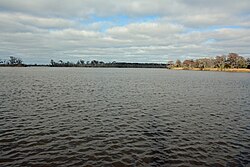
The Altamaha is an ecological sanctuary, featuring river-cut cliffs, cordgrass marshlands, and some of the last remaining old-growth cypress swamps and hardwood bottomlands in the American South. It is the only place in the U.S. to support an old-growth forest of black oak and longleaf pine.
The watershed supports over 120 rare or endangered species. Notable wildlife includes the West Indian manatee, Atlantic sturgeon, shortnose sturgeon, and the Eastern indigo snake. The river is also critical for pearly mussels, with seven species found exclusively (endemic) to the Altamaha.
Historically, the river was the home of the Franklin tree, which was discovered here in 1765 by John Bartram. While now extinct in the wild, descendants of these trees still exist in botanical gardens.
Historical Significance
The river's name is derived from a Yamasee chief named Altamaha. In prehistoric times, the Utinahica tribe lived along its banks, and the Spanish established the mission of Santa Isabel de Utinahica around 1610.
European Settlements and Conflict
Research suggests that Fort Caroline, established by the French in 1564, may have been located near the mouth of the Altamaha. This would make it the oldest European fortified settlement in North America. In 1565, Spanish forces under Pedro Menéndez attacked the fort, killing approximately 143 French Huguenot Protestants.
Commerce and the Timber Trade
During the 19th century, the Altamaha was a vital commercial highway. Timber rafts, some up to 250 feet long, transported logs to the ports of Darien and Brunswick for export to international markets like Liverpool and Havana. Rivermen navigated hazardous bends, such as "Old Hell Bight," where dangerous currents often led to the loss of cargo and life.
Industry and Conservation
Despite its natural state, the river supports significant industrial infrastructure. The 1,759-megawatt Plant Hatch nuclear power plant and a Rayonier paper mill, which produces cellulose fibers for absorbent materials, are both located on the southern bank.
Modern efforts focus on preservation. In 2021, Ingka Investments (part of IKEA's parent company) acquired over 10,000 acres in the basin to restore longleaf pine forests and protect the habitat of the gopher tortoise.
| Feature | Detail |
|---|---|
| Total Length (with Ocmulgee) | 470 miles (760 km) |
| Drainage Basin Size | 14,000 sq mi (36,000 km) |
| Average Discharge | 13,520 cu ft/s (383 m/s) |
| Rare Species | 120+ species (including 7 endemic mussels) |
| Key Tributaries | Oconee, Ocmulgee, Ohoopee |
Frequently Asked Questions
Where does the Altamaha River begin?
The Altamaha River begins at the confluence of the Oconee and Ocmulgee Rivers near Lumber City, Georgia.
Why is the Altamaha River ecologically important?
It is one of the few remaining undammed river systems on the Atlantic coast and supports over 120 rare or endangered species, including endemic pearly mussels and old-growth longleaf pine forests.
What is the significance of Fort Caroline in relation to the river?
Archival research suggests Fort Caroline, potentially the oldest European fortified settlement in North America, was likely constructed near the mouth of the Altamaha River.
How was the river used for commerce in the 19th century?
The river served as a primary transportation route for the timber trade, where massive log rafts were floated downstream to the ports of Brunswick and Darien for international export.
What industries are currently located along the river?
The river's southern bank hosts the Plant Hatch nuclear power plant and a Rayonier paper mill that manufactures cellulose fibers.