Aleppo Plateau: Geography, Geology, and Landscape of Northern Syria
The Aleppo plateau is a low, gently undulating highland region located in northern Syria. Positioned at the northern terminus of the junction between the African and Arabian tectonic plates at the Dead Sea Rift, this plateau serves as a critical geographic feature of the region. It spans primarily across the Aleppo and Idlib Governorates, with the city of Aleppo situated in the north-central portion of the plateau.
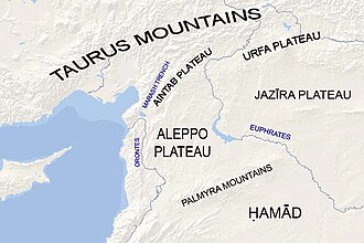
Key Facts
- Average Elevation: 400 meters.
- Geological Composition: Covered by Paleozoic and Mesozoic sediments averaging 4–5 km in thickness.
- Key Waterways: Bounded by the Euphrates River to the east and the Orontes River valley to the west.
- Highest Points: Mount Ḥaṣṣ (550 m) and Mount ʻAqīl (534 m).
- Lowest Point: Maṭkh swamp (249 m).
- Vegetation: Primarily deforested, with pockets of Aleppo pine and oak.
Geographic Boundaries
The plateau is defined by several distinct natural borders. To the south, it is bordered by the Palmyra mountain belt. The eastern boundary is formed by the Euphrates river valley, which separates the Aleppo plateau from the Jazirah plateau. To the west, the northern half of the Dead Sea Rift—specifically the Orontes river valley—marks the edge of the plateau.
Moving northward, the plateau continues as the Aintab plateau, which eventually leads toward the Taurus Mountains.
Topography and Landscape
The surface of the Aleppo plateau is characterized by gentle undulations, with wave amplitudes ranging between 10 and 30 meters. The terrain generally slopes downward in both north-south and west-east directions.
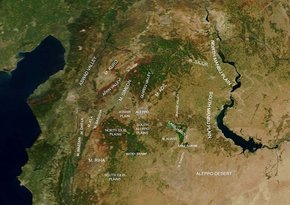
Eastern and Central Terrain
Starting from the Euphrates valley, the land rises to form the Manbij plain before descending again at the Dhahab river valley. The Dhahab river flows north-to-south for approximately 50 km, draining the highlands north of Bāb into Lake Jabboul. West of this valley, the elevation increases at Mount ʻAqīl (534 m) and Mount Ḥaṣṣ (550 m), before dipping again into the valley of the River Quwēq. The Maṭkh swamp, located at 249 m, represents the lowest point in the Aleppo Governorate.
Western Highlands and the Limestone Massif
West of the Quwēq river lies Mount Simeon, followed by the plains of Idlib to the south. The River ʻIfrīn flows between Mount Simeon and Mount Kurd, eventually turning west toward the Orontes valley. This river separates Mount Kurd from Mount Ḥārim. Further south, the Rouj Plain separates Mount Ḥārim from Mount Zāwiya, leading eventually to the Ghab Plain. These western highlands are collectively referred to as the Limestone Massif.
Climate, Soil, and Vegetation
The plateau exhibits varying levels of fertility. The southeastern portion is an arid steppe that marks the northern tip of the Syrian Desert. In contrast, the rest of the plateau—particularly the northwest—is generally fertile.
While the region is largely deforested, a dispersed forest extending about 50 km exists on the eastern slope of Mount Kurd, facing the plain of Aʻzāz. The dominant tree species in these areas are oak and Aleppo pine.
Geological Composition
The plateau's lowlands are underlain by combined Paleozoic and Mesozoic sediments with an average thickness of 4 to 5 km. Isotope analysis reveals that the deeper Upper Cretaceous aquifers (water-bearing rock layers) of the Aleppo plateau share similarities with those in the Palmyrean mountain zone, though they differ from the shallower Paleogene aquifers.
The region also shows evidence of volcanic activity. Intraplate basalts (volcanic rocks formed away from plate boundaries) from the Early–Middle Miocene period indicate two distinct volcanic phases occurring approximately 19–18 million years ago (Ma) and 13.5–12 Ma. These basalts contain lower abundances of platinum-group elements compared to mid-ocean ridge basalts or alkali basalts found in Hawaii.
| Feature | Details |
|---|---|
| Average Elevation | 400 m |
| Sediment Thickness | 4–5 km (Paleozoic and Mesozoic) |
| Key Mountains | Mount Ḥaṣṣ, Mount ʻAqīl, Mount Simeon, Mount Kurd |
| Primary Rivers | Euphrates, Orontes, Quwēq, ʻIfrīn, Dhahab |
| Volcanic Phases | ~19–18 Ma and ~13.5–12 Ma |
| Dominant Flora | Aleppo pine and oak |
Frequently Asked Questions
What are the primary boundaries of the Aleppo plateau?
The plateau is bounded by the Euphrates river valley to the east, the Orontes river valley to the west, the Palmyra mountain belt to the south, and the Aintab plateau to the north.
What is the Limestone Massif?
The Limestone Massif is the collective name for the highlands located in the western portion of the Aleppo plateau.
What is the lowest point of the Aleppo Governorate?
The lowest point is the Maṭkh swamp, which sits at an elevation of 249 meters.
What types of trees are native to the region?
The main trees found in the region, particularly in the dispersed forests on the eastern slope of Mount Kurd, are oak and Aleppo pine.
What is unique about the geology of the plateau?
The plateau features thick Paleozoic and Mesozoic sediments and contains Miocene intraplate basalts that occurred in two distinct volcanic phases, characterized by low platinum-group element abundances.